Brian McMorrow
|
all galleries
>>
Asia
>>
China - 中国
>>
Tibet - 西藏 (བོད་)
>>
Qinghai-Tibet Railroad (Tibet Portion)
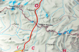
> Map showing the area around Mount Tanggula (6070 m) on the border between Qinghai Province and Tibet Autonomous Region
previous
|
next
01-OCT-2008
Map showing the area around Mount Tanggula (6070 m) on the border between Qinghai Province and Tibet Autonomous Region
Nikon D200
1/160s f/6.3 at 170.0mm iso500
full exif
other sizes:
small
medium
original
auto
previous
|
next
Images are Copyright Brian J. McMorrow
comment
|
share
Type your message and click Add Comment
It is best to
login
or
register
first but you may post as a guest.
Enter an optional name and contact email address.
Name
Name
Email
help
private comment