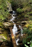
The Pisgah trail map doesn't show a trail up upper Courthouse Creek, but if you look on a topo map you can see a dotted line that represents the old logging road and railroad bed that once was. After leaving Red Rock Falls, the trail continues up the left side of the creek and passes through an area that was just full of Trout Lilies, ramps, and other wildflowers. In less than 1/2 a mile, the trail crosses the creek and begins heading away from the creek. The topo map shows it going all the way up to Devil's Courthouse on the Blue Ridge Parkway, but I haven't been up it that far. From the creek crossing, we decided just to stay in the creek and work our way up. This really nice waterfall is less than 1/4 mile up!