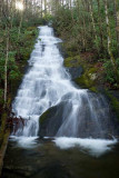
This is the same falls from the base of this section. We estimated it to be 50-60' high. To get here, we parked in the same place as the trip we took on July 6 of last year - on Charleys Creek Rd. But instead of heading down the little trail to where Pinhook Creek meets Tanasee Creek, we walked a short ways back up the road to an old gravel road and took it. It headed kind of east to begin with, then turned south, headed up hill for a ways, then leveled out still heading generally south. We crossed one creek - the second creek was our target. The top of this falls isn't too far down. This was a huge improvement over the trickle Bernie had seen last year!