![]() |
![]() |
![]() |
![]() |
![]() |
![]() |
![]() |
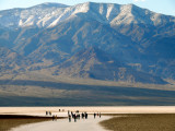
The Badwater Basin is the lowest point in the United States, 282 feet below sea level. Visitors can walk over a mile out onto the saltpans below. They are dwarfed by the Panamint Mountains in the distance. It is this scale incongruity that tells the story. Although there is a crowd of people in this image, that crowd is vastly diminished by the scale of both the mountains and the valley. Although I made this image with a 200mm lens, I was far enough away from my subjects to retain this scale difference.
Full EXIF Info | |
Date/Time | 19-Feb-2007 15:55:18 |
Make | Leica |
Model | V-LUX 1 |
Flash Used | No |
Focal Length | 43.9 mm |
Exposure Time | 1/400 sec |
Aperture | f/7.1 |
ISO Equivalent | 100 |
Exposure Bias | -0.33 |
White Balance | |
Metering Mode | multi spot (3) |
JPEG Quality | |
Exposure Program | program (2) |
Focus Distance |
Image Copyright © held by Phil Douglis, The Douglis Visual Workshops
Phil Douglis | 09-Jul-2008 20:13 | |
Guest | 09-Jul-2008 01:29 | |
Guest | 09-Jul-2008 01:13 | |
Phil Douglis | 02-Jul-2007 20:38 | |
Guest | 02-Jul-2007 20:27 | |
Phil Douglis | 02-Mar-2007 23:03 | |