Dave Beedon
|
all galleries
>>
Places
>>
Utah
>>
Moab (environs)
>>
Jackson Butte
>>
Jackson Butte via Jackson's Trail
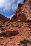
> The top of this slope might be as far as I can go---is there a scrambling route to the top?
previous
|
next
The top of this slope might be as far as I can go---is there a scrambling route to the top?
other sizes:
small
medium
original
auto
previous
|
next
All images are copyright 1966 - 2023 by Dave Beedon (davebeedon AT comcast DOT net).
share
Type your message and click Add Comment
It is best to
login
or
register
first but you may post as a guest.
Enter an optional name and contact email address.
Name
Name
Email
help
private comment
Jason Anderson
24-Mar-2008 23:55
Very considerate of you to provide context for my original comment rather than leave me hanging.
Admittedly PBase has taken a sudden turn for the worse the last few days. Relatively speaking.
Dave Beedon
24-Mar-2008 04:42
Jason, the uploading burped, resulting in the (now-corrected) image orientation.
Jason Anderson
24-Mar-2008 02:26
You're losing perspective, Dave. Considering the steep incline, I'm impressed you made it this far.
Does water always fall sideways near Moab?
Type your message and click Add Comment
It is best to
login
or
register
first but you may post as a guest.
Enter an optional name and contact email address.
Name
Name
Email
help
private comment