


|
|
|
|
|
|
| |
| 04-JUL-2005 | Dave Beedon |
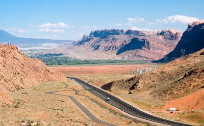
Looking south from the main road in Arches National Park, just uphill from its entrance. In the
distance at left is Moab. Between the greenery and the tiered orange hill is the Colorado River,
flowing from left to right and going through the opening in the ridge called The Portal. The low
tiered hill at center covers uranium tailings at the former site of a uranium processing plant.
.
| Full EXIF Info | |
| Date/Time | 04-Jul-2005 17:47:47 |
| Make | Nikon |
| Model | D100 |
| Flash Used | No |
| Focal Length | 60 mm |
| Exposure Time | 1/160 sec |
| Aperture | f/11 |
| ISO Equivalent | |
| Exposure Bias | |
| White Balance | (9) |
| Metering Mode | matrix (5) |
| JPEG Quality | (6) |
| Exposure Program | manual (1) |
| Focus Distance | |
All images are copyright 1966 - 2023 by Dave Beedon (davebeedon AT comcast DOT net).