


|
|
|
|
|
|
| |
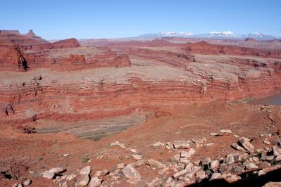
| 12-APR-2006 | Dave Beedon |
Looking east-southeast. On the horizon about one fourth picture width
from the left edge is the tilted red cliff at Thelma and Louise Point
( http://www.pbase.com/listorama/image/60182148 ). The green plateau in
front of it is where I took pictures earlier in the day.
The right edge of the wider green mesa is the narrowest part of The
Gooseneck. A cliffy canyon there (thin white bands) marks the limit of
mesa exploration and makes a "southern approach" to the mesa impossible.
.
All images are copyright 1966 - 2023 by Dave Beedon (davebeedon AT comcast DOT net).
| 1moremile | 16-May-2006 09:22 | |