


|
|
|
|
|
|
| |
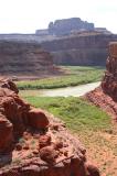
| 9 Jul 2004 | Dave Beedon |
Another view to the southwest of the northern tip of The Gooseneck (dark slope in left
distance). The river is flowing from left to right. The stream canyon in the foreground
is directly southwest of Dead Horse Point State Park (DHPSP). This landscape is
often photographed from the park, where it looks much different.
.
All images are copyright 1966 - 2023 by Dave Beedon (davebeedon AT comcast DOT net).