


|
|
|
|
|
|
| |
| 3 Jul 2004 | Dave Beedon |
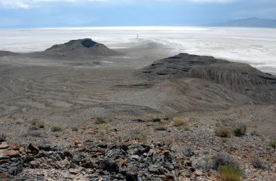
Looking southwest at the Bonneville Salt Falts. At top right: the Silver Island Mountains. Interstate 80 is about 17 miles
away, straight ahead. The dark, meandering line at top center is a drainage channel (and possibly a dike). Just above
the straight portion of that channel is the northeast end of the Bonneville Speedway; it is just barely discernable
in the next photo.
| Full EXIF Info | |
| Date/Time | 03-Jul-2004 15:07:34 |
| Make | Nikon |
| Model | D100 |
| Flash Used | No |
| Focal Length | 28 mm |
| Exposure Time | 1/125 sec |
| Aperture | f/16 |
| ISO Equivalent | |
| Exposure Bias | 0.67 |
| White Balance | (9) |
| Metering Mode | matrix (5) |
| JPEG Quality | (6) |
| Exposure Program | manual (1) |
| Focus Distance | |
All images are copyright 1966 - 2023 by Dave Beedon (davebeedon AT comcast DOT net).