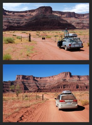
Looking west on San Juan County Route 142 (often called "Shafer Trail"), southwest of Moab, Utah. In the lower image, Dead Horse Point is visible.
The upper photo, shot in 2004, shows my Subaru station wagon. Below that is the Green Weenie (my Toyota Sienna) at the same place in 2008, facing a cattle guard. In the earlier photo a gate spanned the road, but later the gate was moved to the left and a cattle guard was installed in the road. Now drivers don't need to get out of their vehicles to open and close a gate. Cattle graze here now and then on this BLM land.
20040709_2737 and 20081017_2074
|