


|
|
|
|
|
|
| |
| 03-NOV-2017 | |
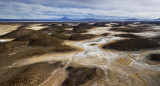
2 Aerial photo stitched of the Coipasa Salt Flat, Spanish Salar de Coipasa, salt flat, in the arid but colourful Altiplano of Bolivia, about 100 miles (160 km) southwest of the city of Oruro, near the Chilean border. At an elevation of 12,073 feet (3,680 metres), the flat, Bolivia’s second largest (after Uyuni Salt Flat), occupies 856 square miles (2,218 square km). Lake Coipasa directly to the north receives the intermittently flowing Lauca River from the northwest and is connected to Poopó Lake to the east by the Lacajahuira River.
| Full EXIF Info | |
| Date/Time | 03-Nov-2017 07:40:45 |
| Make | DJI |
| Model | FC220 |
| Flash Used | No |
| Focal Length | 4.7 mm |
| Exposure Time | 1/233 sec |
| Aperture | f/2.2 |
| ISO Equivalent | 100 |
| Exposure Bias | |
| White Balance | |
| Metering Mode | |
| JPEG Quality | |
| Exposure Program | |
| Focus Distance | |
Yiannis Pavlis.All rights reserved. Please e-mail me if you are interested to use or purchase images.
| MarcViskens | 11-Dec-2017 18:21 | |
| Tom LeRoy | 11-Dec-2017 15:18 | |
| Gill Kopy | 11-Dec-2017 04:37 | |
| Stephanie | 10-Dec-2017 20:03 | |
| Robert Houde | 10-Dec-2017 18:52 | |
| Marcia Colelli | 10-Dec-2017 14:35 | |
| Helen Betts | 10-Dec-2017 14:07 | |
| joseantonio | 10-Dec-2017 05:35 | |