photo sharing and upload picture albums photo forums search pictures popular photos photography help login
clamflats | all galleries >> Alaska, Fall 1994 >> Denali Highway and Denali Itself > Denali Hwy topo map
previous | next

Denali Hwy topo map

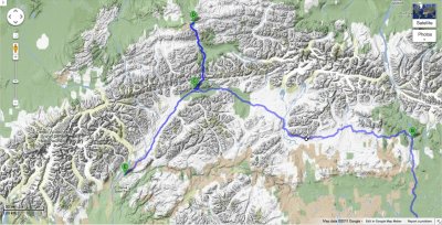
Showing the high elevation and the ruggedness of the surroundings.

The dot is just below the Clearwater Mountains. The Amphitheater Mountains are about halfway between the dot and the "B", which marks the eastern end of the highway.


other sizes: small medium large original auto
share
Type your message and click Add Comment
It is best to login or register first but you may post as a guest.
Enter an optional name and contact email address. Name
Name Email
help private comment