


|
|
|
|
|
|
| |
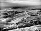
| APR-1942 | Florida State Archives |
World War II was getting into full swing when this photo of Pan American Field was taken. This view is looking WSW from over the southeast tip of Hialeah. Eastern had some buildings in the left-middle and middle of the photo. Okeechobee Road runs diagonally from lower left to lower right. A bridge for LeJeune Road over the Miami Canal hasn't been built yet so traffic must have used the NW 36th Street bridge. Southeast Hialeah and Miami Springs are mostly undeveloped in what can be seen. Hangars extend westward along the south side of NW 36 Street with the Pan American hangars furthest out. It appears that this airport had four runways.
Unless noted, all photos are copyrighted Sunbird Photos by Don Boyd (AviationStockPhotos.com and AviationPhotoPrints.com)
| comment | |