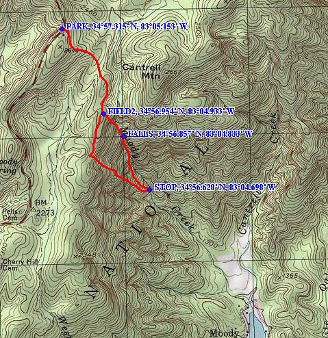
I was back up at Harry's this week end with no plans at all in mind of what we were going to do. Since the weather was supposed to be a little chilly, we thought of stuff in South Carolina we hadn't done and came up with Moody Creek off of Hwy 107. Here's something new also - a topo map with coords. Most of the hike is fairly easy, but the steep part down to the creek is really steep as you can see from the map. For those of you who have never seen a topo, the light brown lines on this one represent a 20' change in elevation, the darker lines are a 100' change. So if the lines are close together, the terrain is really steep. If a creek happens to be in the area, there is falling water. It might be in the form of a waterfall, might be cascades, there might be a lot of fallen logs and debris, there might be a lot of shrub obscuring a nice waterfall, there might be cliffs that you can fall off of and die, and so on. Bottom line is you don't know if you don't go, but if you go you better have off trail scrambling skills. Rescue will be hours away.
I have had a couple of folks email me saying they checked it out, so we decided to also. PARK on the map is FS733 which is 4.7 miles south of Wiggington Rd on Hwy 107 in SC. The dirt road is gated so we parked there and walked about 10 minutes to a fork, then went right at the fork. Not too far ahead is a grassy wildlife clearing - we headed through that, then a very short distance to a 2nd clearing which is FIELD2 on the map. On the left side of the field is a faint trail leading into the woods. We headed down that, then veered off to the left and headed down into the gorge. FALLS on the map is the appr. location of the 1st nice waterfall we saw. STOP is for Bernie - that's the place where we decided it wasn't worth the effort to go any farther - and that was too far. Then we headed straight up back to the ridge which is about 800' in elevation change. The only good thing is that it is mostly open woods - no cliff areas that we often come across.