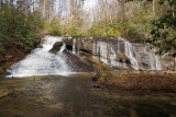
The old forest road isn't used any more, but it's marked on the topo and easy to follow. After about 20 minutes we had to cross Limber Pole Creek, then continued towards Howard Creek. Bernie and John had been doing recon missions and had already found this waterfall by following the road all the way to Howard Creek, then heading down creek about 1/4 mile to the waterfall. But on this trip Bernie wanted to try cutting through the woods in the flat area to the left of the word 'Howard' on the map. Worked like a charm, just like the map showed. This waterfall is 15-20' high.