


|
|
|
|
|
|
| |
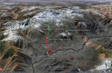
The black line roughly marks the Karakoram Highway, the red line is a very rough representation for the jeep track up to Tato village and the green line represents the walking trail up to Fairy Meadows and the northern Base Camp.
Download this collection of 700+ Northern Pakistan placemarks (Google Earth file). This collection marks many towns, rivers, glaciers, peaks, passes and base camps in Northern Areas and NWFP.
Waqas Usman
| comment | |