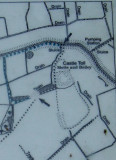
The elongated area within the dotted line,represents the more ancient site within which Castle Toll sits.This is thought by many,but not all,historians,to be the site of Eorpeburnan,attacked by the Danes in 892AD.The river,embanked,running past the site,is the Hexden Channel.It is thought that in Saxon times,the sea level was higher than today,and Danish longships could easily have sailed right up to this site.
see http://www.fortifiedengland.com/Home/Categories/ViewItem/tabid/61/Default.aspx?IID=2764
see http://www.pastscape.org.uk/hob.aspx?hob_id=417477
see http://castlefacts.info/castledetails/castleDetails3.aspx?uin=11601