photo sharing and upload picture albums photo forums search pictures popular photos photography help login
Steve, Katherine, and Norah | profile | all galleries >> Peru 2018: The Alpamayo Circuit >> The Alpamayo Circuit tree view | thumbnails | slideshow

The Alpamayo Circuit

The Cordillera Blanca, named for its glaciers and snow capped peaks, is a 200 km/124 mile long mountain range in the Andes. Most of the range is contained within Huascarán National Park, home to the highest mountain in Peru by the same name (Huascarán is 6,746 m/22,132 ft tall). The Cordillera Blanca contains many big, dramatic mountains; glaciers, turquoise alpine lakes, and beautiful valleys, making it a popular destination for climbers and trekkers. It is also home to indigenous Quechua families and their small farms, which we passed multiple times on the trail. We also frequently saw livestock in the valleys (or in one unexpected instance, pigs at a pass!).

The most popular trek in the Cordillera Blanca is the Santa Cruz trek, a four day hike in the Quebrada Santa Cruz south of Alpamayo that covers 50 km/31 miles. Our route on the Alpamayo Circuit followed the Santa Cruz trek the first three days and accordingly we saw many hikers. Once we diverged from the Santa Cruz trek, we left the crowds behind and we rarely saw other hikers - only four times in eight days. This also meant the trail was not always as well defined or marked, so if hiking independently it’s important to be familiar with the route and have a good map for navigation (this is the map we had, although it appears it’s not longer available new). The Santa Cruz portion of the trek was beautiful, but I would highly recommend the full circuit if time and ambition allow. The full experience is really amazing and it’s really nice to have all that gorgeous scenery to yourself.

The Alpamayo Circuit, also referred to as Cedros Alpamayo, crosses seven passes as it circumnavigates Alpamayo from the villages of Cashapampa to Hualcayan (the route can be hiked in either direction, this is the direction we chose). It’s difficult to find information on distances and I’ve seen multiple webpages list 140 km/87 miles for the trek, although I think this is being generous. I think the trek is likely closer to 120 km/75 miles (plus additional miles for any side hikes). I wasn’t always diligent about paying attention to our hiking time, but I estimate we hiked around 50 hours (excluding extended breaks) with 5640 m/18,504 ft elevation gain and 5400 m/17,717 ft elevation loss. We took eleven days for the trek and the bulk of the hiking was done in nine days (we had one rest day and our last day was a short one), which is about 13 km/8 miles a day with 626 m/2056 ft elevation gain. That certainly doesn’t sound bad at all (and is less than other trips we’ve done), but it was harder than it sounds thanks to the altitude. Our hike started at 2900 m/9514 ft and we spent most of our time above 3960 m/13,000 ft, topping out at 4830 m/15,846 ft on Gara Gara Pass. We were never sick from the altitude beyond some headaches in the beginning, but we could certainly feel its affect and we felt sluggish at times.

The altitude required we spend several days acclimating before our trek. Huaraz is the jumping off point for trekking in the region and we flew there from Lima. We spent one night in Huaraz (3050 m/10,010 ft) and then moved to Caraz (2256 m/7402 ft) for two nights to be closer to our day hikes and the start of the Alpamayo trek. I think travelers are often squeezed for time and are tempted to forgo enough time for acclimatization, but I think it’s worthwhile to give your body time to adjust (and there are plenty of great hikes to do in these few days). We knew from our previous trip that three days worked well to acclimate and it worked well again this trip. It certainly helped us feel ready for our trek and we never had issues with the altitude.

While it is possible to do the Alpamayo Circuit independently, we opted to again do a supported trek organized by Chris Benway at Cima Logistics in Huaraz. Our trip was very similar to our Huayhuash trek - we even had the same cook, Joel, so it was nice to see him again. He was joined by Cesar (guide), Tony and Elmer (arrieros), seven burros, and an extra horse. We had paid for an extra horse last time for “just in case” scenarios and we never needed it. This time Norah milked it for all it was worth and often hitched a ride.

We find for our backpacking trips that we like to be able to hike at a comfortable pace and have ample time for breaks, photography, and side excursions, so we often plan generous itineraries. We also like to build in a few extra days in case we have bad weather, want to day hike, or otherwise need to make itinerary changes. Keeping this in mind, we decided on eleven days for our trek. We did end up using a rest day at Jancapampa and our last day was a short one, so it was primarily nine days of hiking. One advantage of either hiking independently or doing a privately guided trip is flexibility in the schedule and the ability to take our time where we wanted to. Luckily on this trip we didn’t have to burn any days for weather. Overall we felt we our itinerary worked well.

We fell into a routine that had us hiking by eight most mornings. We would have breakfast, filter water for the day, pack our day packs, pack the rest of our gear in the duffle bags for the donkeys, and hit the trail. Within an hour or less our team and donkey train would pass us by; this is when Norah would often ride the horse for a bit as we climbed to a pass. We aimed to hike a nice and steady pace to avoid overexertion, which we found could lead to headaches at altitude. We had plenty of time for extended breaks and shorter breaks throughout the day. We typically arrived to camp around three in the afternoon and would have afternoon tea and a snack, get our tent organized, take a short hike, read, play Uno, or just relax with the great views. Sunset was around six pm and this is usually when we had dinner. Once the sun went down it would get cold quickly and we didn’t linger long after dinner, except for a little star gazing or nighttime pictures. We were usually in the tent and asleep by eight (which seems to be also when the cows would appear at our campsite).

A great thing about hiking in the Andes during the dry season (May to September) is you are likely to have good weather and this held true for us. We had some gray days that were cloudy, but we never had to break out the rain gear nor lost any days due to rain. It was comfortable hiking temperatures during the day and chilly at night. The scenery was beautiful every day, but really popped when we had sun and blue skies. Without a doubt, our favorite day was the day we hiked over Gara Gara Pass and to Jancarurish. It was stunning! We joked that we must have a thing for the double named passes because Tupatupa was another favorite pass.

Our amazing Huayhuash trek in 2016 set the bar very high. While we agree that the Huayhuash trek gets the slight edge, the Alpayamo Circuit was also an awesome adventure and we loved our time spent in the Cordillera Blanca. Without a doubt we’ll be back to Peru!
Days 1 and 2: Cashapampa to Alpamayo Base Camp
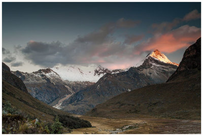
:: Days 1 and 2: Cashapampa to Alpamayo Base Camp 
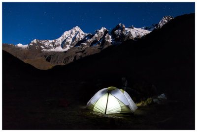
::
Day 3: Alpamayo Base Camp to Tuctubamba via Punta Union
:: Day 3: Alpamayo Base Camp to Tuctubamba via Punta Union 
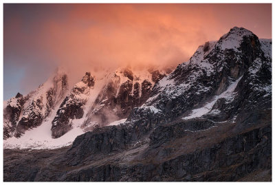
::
Day 4:  Tuctubamba to Huecrucocha via Alto de Pucaraju
:: Day 4: Tuctubamba to Huecrucocha via Alto de Pucaraju 
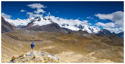
::
Days 5 & 6: Huecrucocha to Jancapampa via Tupatupa  (& a rest day)
:: Days 5 & 6: Huecrucocha to Jancapampa via Tupatupa (& a rest day) ::
Day 7: Jancapampa to Huillca via Yanacon Pass
:: Day 7: Jancapampa to Huillca via Yanacon Pass ::
Day 8: Huillca to Jancarurish via Gara Gara Pass
:: Day 8: Huillca to Jancarurish via Gara Gara Pass ::
Day 9: Jancarurish to Osoruri via Vientunan Pass
:: Day 9: Jancarurish to Osoruri via Vientunan Pass ::
Days 10 and 11: Osoruri to Hualcayan
:: Days 10 and 11: Osoruri to Hualcayan ::