11-JAN-2014
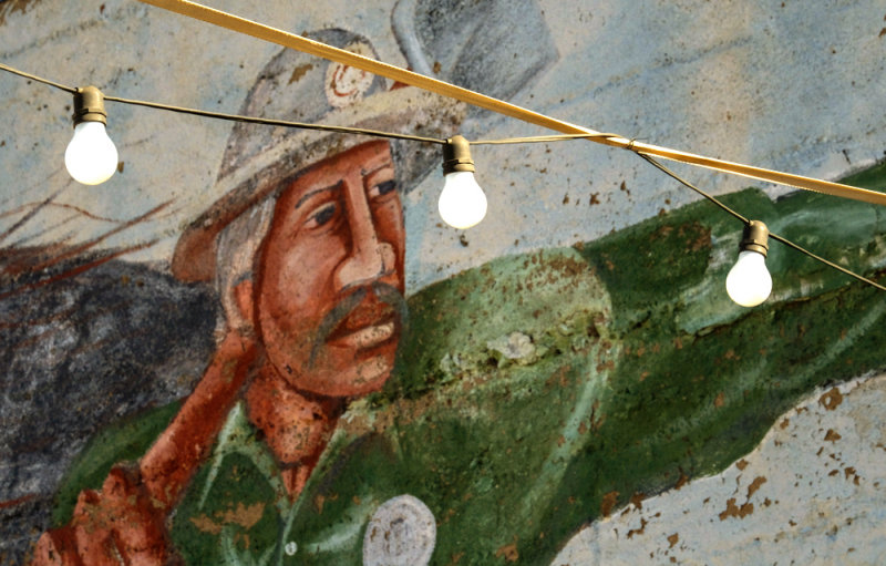
Mining memory, Superior, Arizona, 2014
I zoomed in on this eroding mural overlooking one of Superior�s many vacant lots � the miner recalls the copper mining heritage that flourished here over 100 years ago. Mining ceased here in 1995, but it still offers an identity to this town of only about a thousand people. I layered this image with crossed wires and three light bulbs. None of them are illuminated.
11-JAN-2014
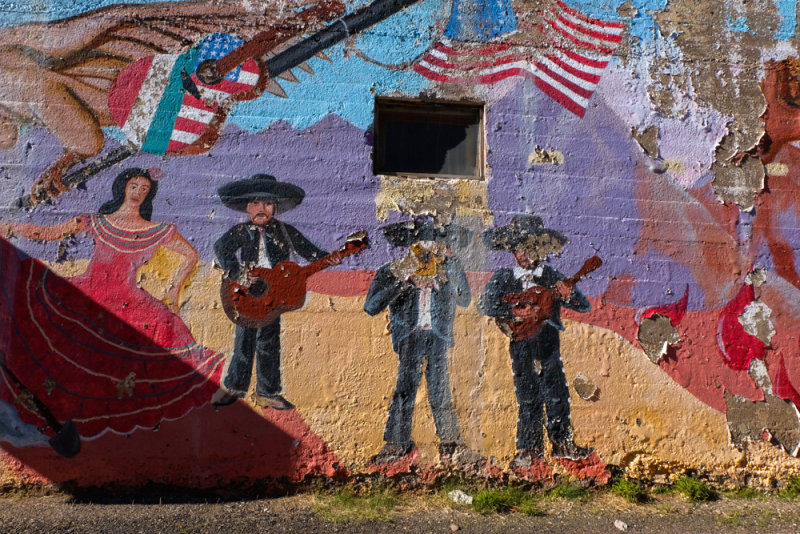
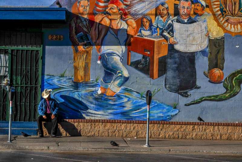
Decaying mural, Superior, Arizona, 2014
This mural once celebrated the blending of two cultures and two countries � the United States and Mexico. Today its colors still draw the eye, although the ravages of time, and perhaps vandals as well, obliterate two of the musicians. I built my image around the diagonal thrust of the shadow at lower left and the diagonal flow of the guitar at upper left. Mexican and American flags decorate that guitar, symbolizing two cultures united by a common love for music.
11-JAN-2014
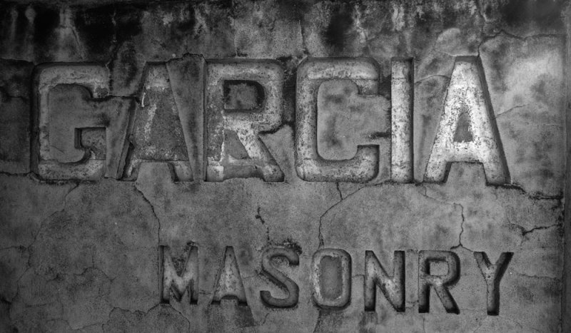
Signage, Globe, Arizona, 2014
While passing through the old mining town of Globe, I noticed that the sign for this masonry business was riddled by small cracks. I moved in that detail, creating a sense of incongruity in the process. Since the sign was already gray, with faded remnants of white paint, I rendered this image in black and white.
11-JAN-2014
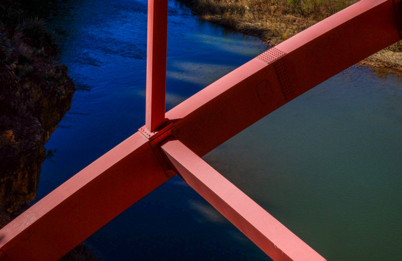
Primary Colors, Salt River Canyon, Arizona, 2014
I abstract the huge bridge over the canyon by framing only parts of its red steel girders. I positioned the largest beam as a powerful diagonal running from corner to corner. The two smaller beams offer context. I designed this image to contrast the red steel to the rich blue water of the river running below it. Red and blue are primary colors, and when seen in combination, the effect defines power and energy.
11-JAN-2014
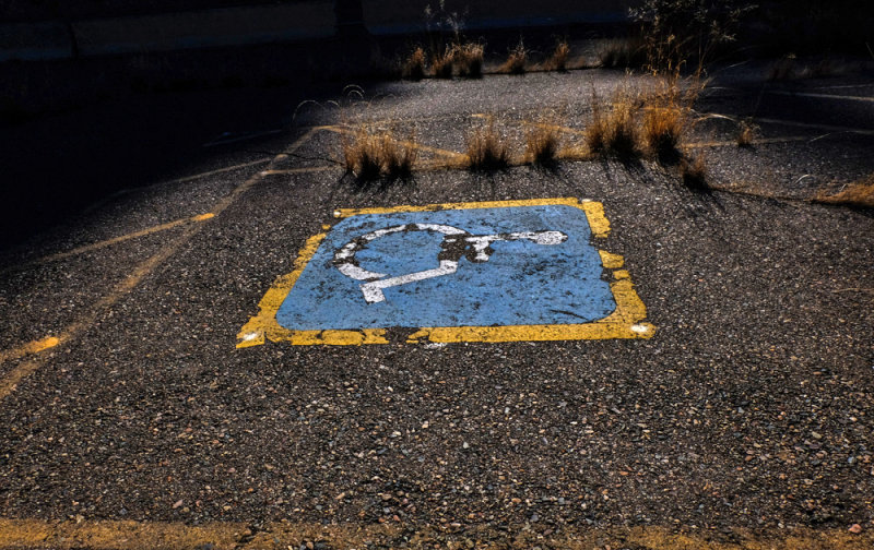
Abandoned rest area, Salt River Canyon, Arizona, 2014
This rest area, near the bridge over the Salt River Canyon, was most likely abandoned as a result of state budget cuts during the last recession. I use two of the three primary colors � in this case blue and yellow � to define the result. Nature itself is reclaiming the concrete surface of what once was a handicapped-parking slot, as ranks of oncoming weeds slowly make their advance.
11-JAN-2014
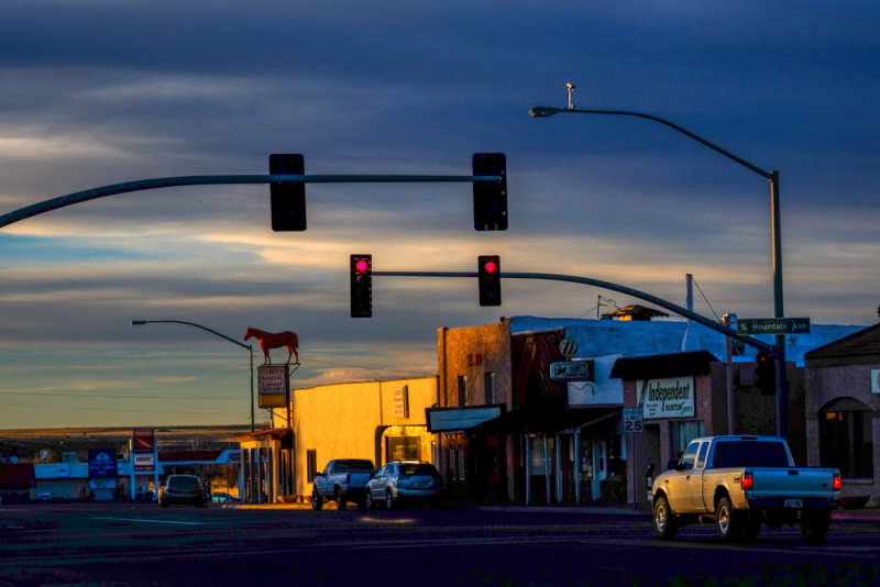
Evening falls, Springerville, Arizona, 2014
The main street of this small town looks quite ordinary until we notice a larger than life red horse standing atop a Western wear sign just down the block from us. This incongruity, along with the warm light of the setting sun, makes a quite ordinary place seem extraordinary. The pair of bright red stoplights, echoed by the glowing taillights of the truck at right, adds a cautionary counterpoint to an otherwise peaceful scene.
12-JAN-2014
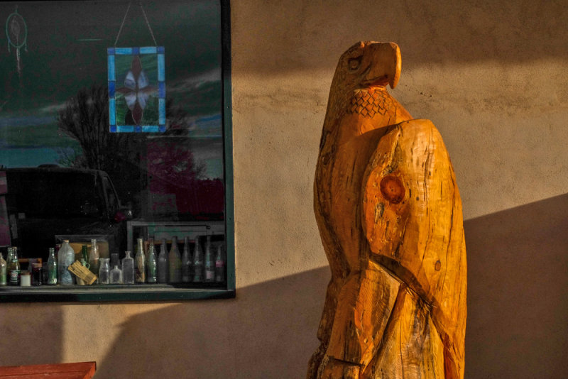
Country Store, Quemodo, New Mexico, 2014
This huge wooden eagle was carved with a chain saw. It stands before the only store we found in this tiny hamlet located along the nearly deserted US Route 60 in the wind-swept hills of western New Mexico. The early morning light gilds the carving, as well as defining the old bottles lining the bottom of the window in the background.
12-JAN-2014
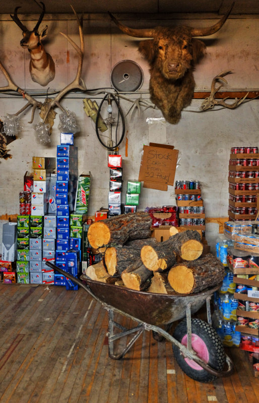
Storage Room, Country Store, Quemodo, New Mexico, 2014
The incongruous juxtaposition of mounted animal heads, antlers, skulls, soft drinks and firewood offer the flavor of country life in this isolated hamlet. I moved in with a 24mm wideangle focal length to embrace the entire scene, yet remain close enough for detail to come through.
12-JAN-2014
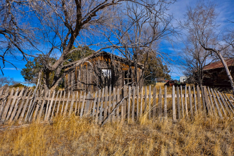
Abandoned home, Pie Town, New Mexico, 2014
Pie Town sits 8,000 feet high, atop the Continental Divide along Highway 60 in Western New Mexico. It has always been known for its pies, and for its place in photographic history. In 1940, Russell Lee, a documentary photographer working on assignment for the Farm Security Administration of the US Government, photographed Pie Town and its people near the end of the Great Depression. The tiny town was then intact � its main street looking like a scene from an old cowboy movie. Lee was among the few photographers to use the new Kodachrome film for his images.
Today, much of Pie Town lies in ruins. I photographed this homestead, layering the image by using a 24mm wideangle focal length to stress first the high weeds, then the sagging picket fence, and finally the ghostly trees framing the weather-beaten house.
12-JAN-2014
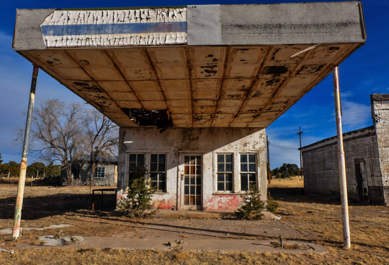
Gas station, Pie Town, New Mexico, 2014
My 24mm wideangle focal length emphasizes the canopy over this abandoned gas station in Pie Town by distorting it. It makes the front panel on the canopy seem much larger than it really is, thereby stressing the remnants of its peeling paint, as well as the corroding ceiling under the canopy.
12-JAN-2014
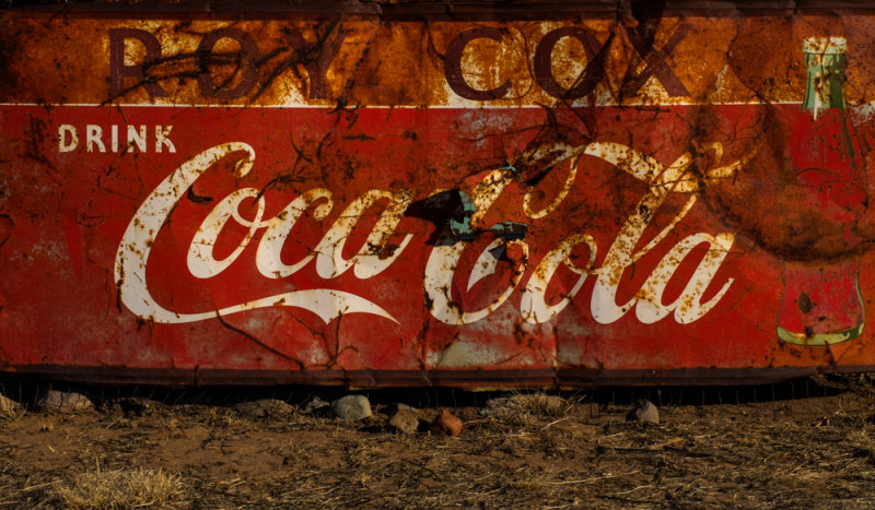
Coca Cola signage, Pie Town, New Mexico, 2014
The surface of this decaying sign symbolizes Pie Town�s rise and fall. The product was intended to bring enjoyment to the long departed residents of this place. Today, the bottle pictured at right has virtually faded away, just as the town has. Meanwhile, rust has nearly obliterated the name of the man who ran the store where this drink was sold.
12-JAN-2014
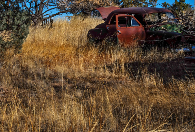
Requiem, Pie Town, New Mexico, 2014
Nearly 75 years ago, Russell Lee came to this place to document the deprived living conditions of those who once lived here. His images, along with those of fellow FSA documentary photographers such as Dorthea Lange, Walker Evans, Arthur Rothstein, and Gordon Parks, helped create an American cultural myth out of a ravaged rural nation. I�ve recalled Lee�s Pie Town imagery here with an offering of my own � a vintage automobile at the end of its trail, lying at rest in a field of golden weeds.
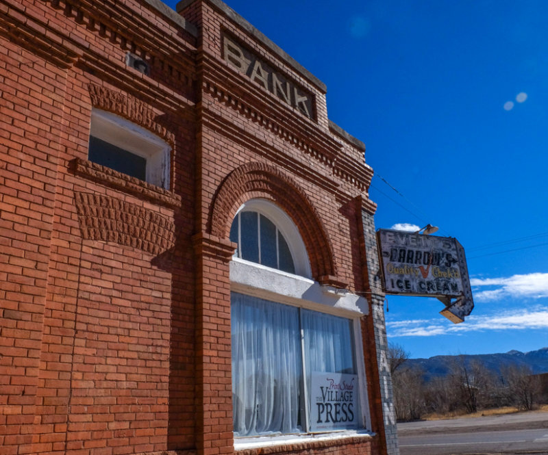
12-JAN-2014
Transformations, Magdalena, New Mexico, 2014
Magdalena was once a thriving silver mining town. Its wealth was funneled through this sturdy brick bank building until the silver market collapsed. The bank is gone, yet the weathered signage tells us that this building has since hosted at least a soda fountain and ice cream shop. More recently, a printing company has placed its sign in the curtained window. Today, this 900 person, high desert town is trying to transform itself into an art center and cultural destination. This image may lead us to wonder what else may in store for this handsome vintage structure.
12-JAN-2014
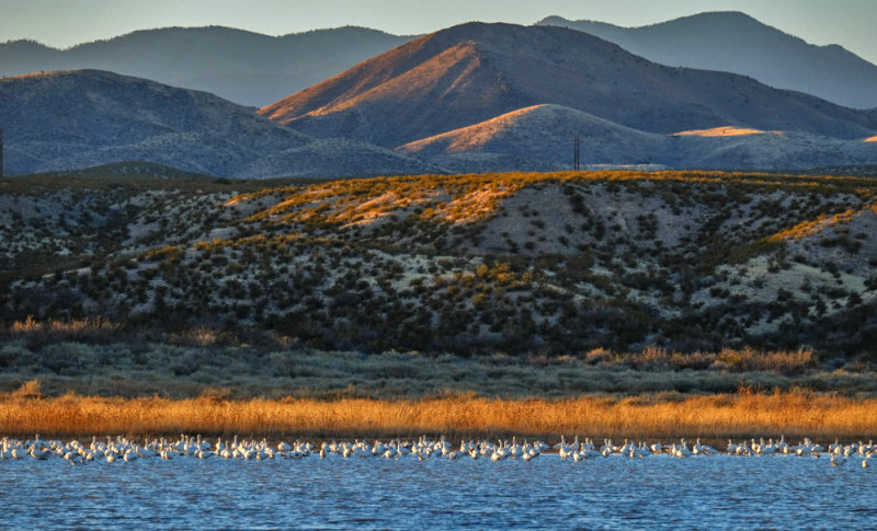
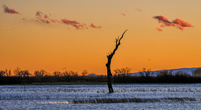
Layers, Bosque del Apache National Wildlife Refuge, New Mexico, 2014
More than 20,000 migrating snow geese spend their winters in this remote refuge on the banks of the Rio Grande River. I arrived at this river at sunset, and built this image around four stacked layers. The white geese float on the river at the bottom of my frame. A layer of golden weeds crowns the geese. Behind them a riverbank rises, covered in brush. The background layer adds a stack of soft mountains, molded by time. The last light of day moves through the image from bottom to top.
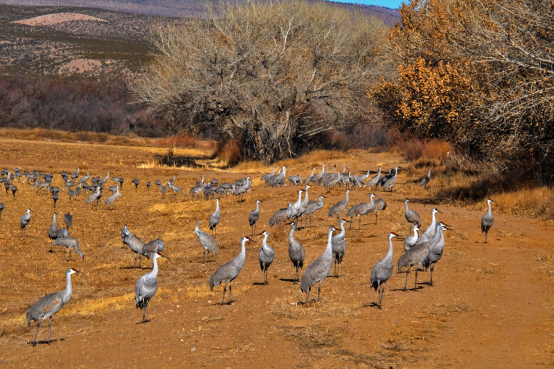
12-JAN-2014
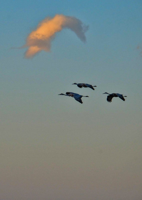
Sandhill Cranes, Bosque del Apache National Wildlife Refuge, New Mexico, 2014
More than 10,000 migrating Sandhill Cranes winter here as well. During the day, they feed in the surrounding irrigated farms and wetlands. At sunset, they commute to the waters of the Rio Grande. I caught this trio of cranes approaching the river below a curving golden cloud.
12-JAN-2014
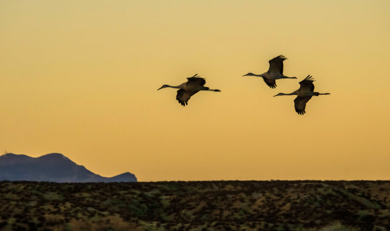
Fly-in at sunset, Bosque del Apache National Wildlife Refuge, New Mexico, 2014
I caught these three Sandhill Cranes on their final approach to the Rio Grande River just after sunset. The negative space between the birds crackles with energy. They summer in the Great Plains, and migrate to the Rio Grande every winter in huge numbers.
13-JAN-2014
Feeding cranes, Bosque del Apache National Wildlife Refuge, New Mexico, 2014
Sandhill Cranes root around for seeds and other foods in the shallow wetlands of this refuge. They eat during the day, fly a short distance to the Rio Grande in the evening, and then fly back out to the fields the next morning. The irrigated farmland in this refuge produces quantities of waste corn, wheat, and sorghum as nutrients. During our second day in the refuge, we passed fields that supported thousands of these cranes. This group was feeding fairly close to the road. They allowed me to get reasonably close before scurrying off.
13-JAN-2014
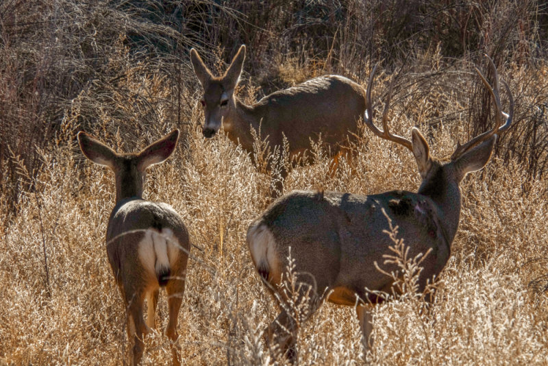
Mule deer, Bosque del Apache National Wildlife Refuge, New Mexico, 2014
Mule deer are instantly identified by their large, mule-like ears, and black-tipped tails. We encountered this trio walking alongside of the road in the wildlife refuge. They scattered as we passed them, then traveled in a complete circle around us. Trying to compose a coherent image from a car window proved impossible. We pulled off the road, and I was able to find them coherently grouped in this tight circle as they stood amidst the stalks of dead weeds in the forest.
13-JAN-2014
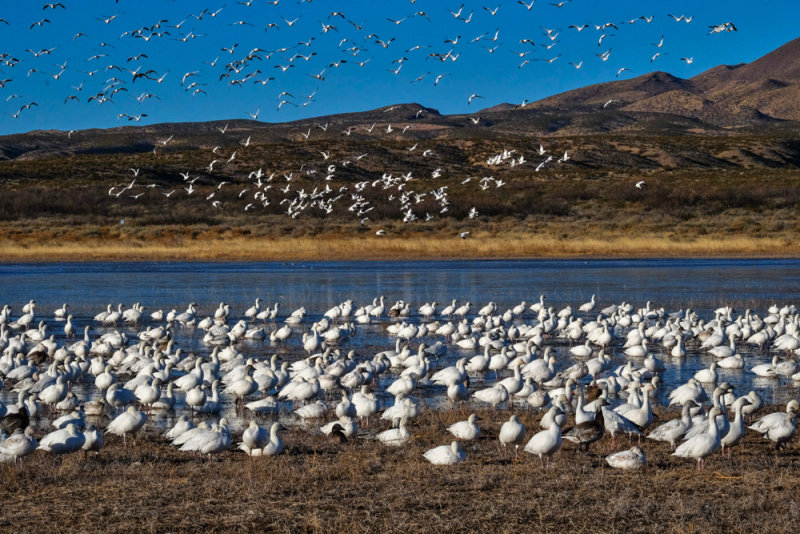
Morning fly-out, Bosque del Apache Wildlife Refuge, New Mexico, 2014
Thousands of Snow Geese fly out from the Rio Grande River for a day of feeding in this wildlife refuge. Meanwhile, a huge group of geese remain standing in the shallows of the river in the foreground, while the sky is filled with them in the background. Seconds after I made this image, the group of standing geese lifted off as well, and we were enveloped in a cloud of feathers, amidst thunderous squawks. Because the geese in the foreground were standing still while those in the background were in flight, I was able to compose this image relatively coherently. The geese on the water offer a foreground anchor, while the curtain of geese covering the hills and the sky in the background offers a striking counterpoint.
13-JAN-2014
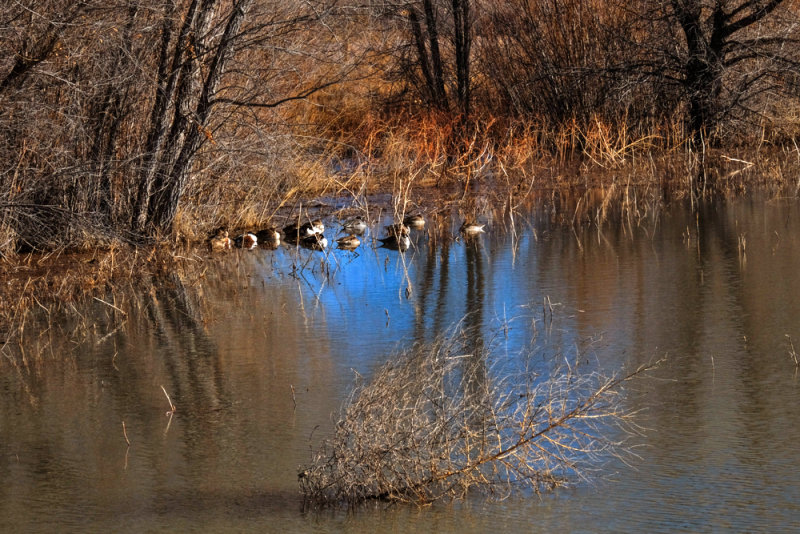
Ducks at rest, Bosque del Apache Wildlife Refuge, New Mexico, 2014
These ducks float silently in a cove on the Rio Grande River. The sun is going down, and the bushes in the water with them show their winter colors. I was drawn to this scene for its reflections, and how they work with the subject. Two clusters of trees flank the ducks, and their reflections create protective brackets around them. The water itself seems to be providing shelter for these slumbering ducks.
12-JAN-2014
The Sentinel, Bosque del Apache Wildlife Refuge, New Mexico, 2014
Ranks of grasses and long dead trees mark the course of the Rio Grande as it flows through this sanctuary. This particular tree looked like a symbolic soldier shouldering a rifle, a lone sentinel guarding this vast wildlife refuge. The setting sun provides the color, as I watched a procession of small clouds float in the background. I waited for the clouds to frame the tree, and then made this image.
13-JAN-2014
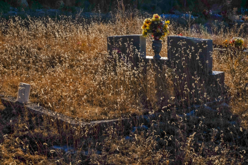
Cedarvale Cemetery, White Oaks, New Mexico, 2014
This small cemetery dates from the 1880s. Its occupants reflect the early history of New Mexico -- its first governor and the discoverer of the Mother Lode gold mine are buried here, and so is a deputy sheriff gunned down by the outlaw Billy the Kid. What made this cemetery special for me, however, were the high grasses that enveloped the graves. In the late afternoon light, the grasses bathed the graves in gold and helped me to abstract them. In this image, I photographed these grasses in backlight. Their tiny leaves become a field of floating particles hanging in the air over a pair of graves. The yellow flowers in the urn between the tombstones anchor the image.
13-JAN-2014
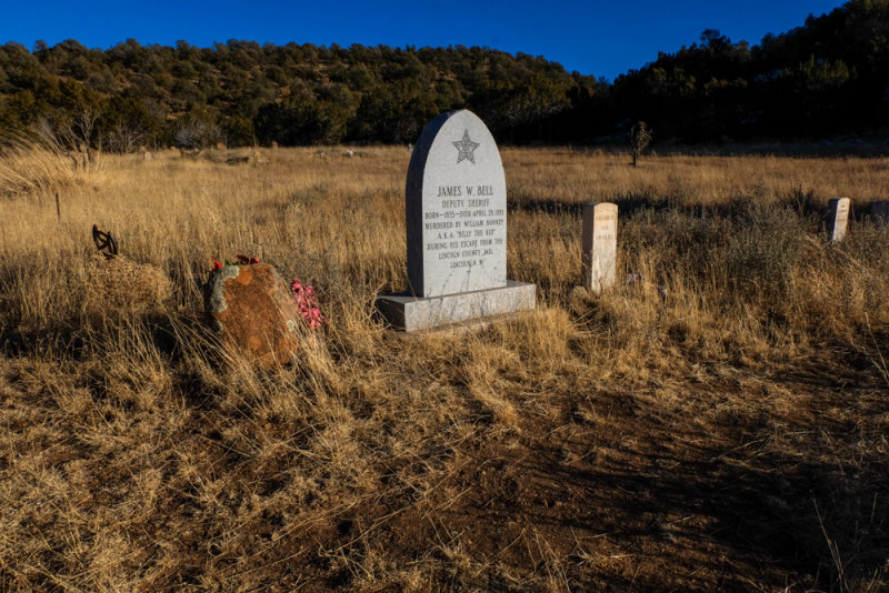
Echoes of the Wild West, Cedarvale Cemetery, White Oaks, New Mexico, 2014
The most famous grave in this cemetery belongs to James W. Bell, a twenty eight year old deputy sheriff. Frontier outlaw Billy the Kid murdered Bell during his escape from the Lincoln County Jail on April 28, 1881. Bell was buried in this cemetery, but his grave had been poorly marked. It was recently rediscovered, and a new headstone was installed. I photographed it in late afternoon light, among the golden weeds where his bones have rested for 133 years. Bell�s gravestone may be new, yet the neighboring stones to its left and right are original, dating back to the early years of the cemetery. It is the incongruity in size and condition of these stones that give this picture it�s meaning.
13-JAN-2014
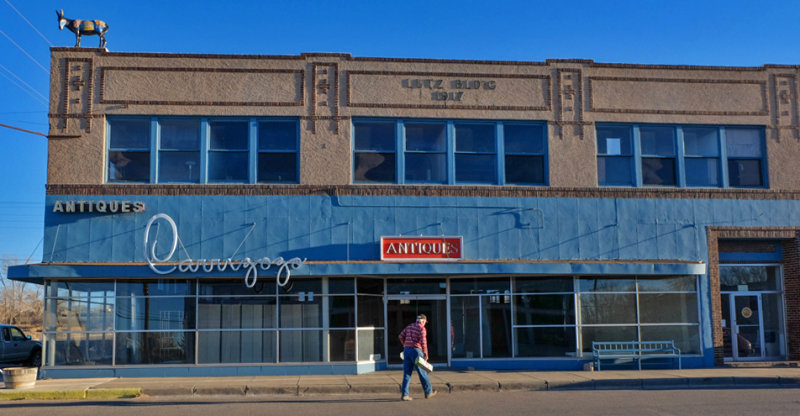
A sense of place, Carrizozo, New Mexico, 2014
Simple economics have determined the nature of this small town. It started as a railroad stop in 1899. The railroad brought business, as well as a county seat, to Carrizozo. This building went up in 1917, when Carrizozo was booming. With rise of the automobile, the railroad�s importance diminished. The last passenger train passed through in 1968, and by the end of the 20th century only a thousand or so people lived here. The very nature of this building, built in 1917, offers a sense of this place today. The name of the town is scrawled in neon along its fa�ade. It seems to be a ghost building � its rooms appear to be vacant. Yet a life sized sculpture of a burro stands incongruously atop the structure. Other burro sculptures line the town�s main street. The sole figure in the picture (and the only person we met in this town) turned out to be the husband of the local artist who created those burros. The burro sculptures symbolize Carrizozo�s effort to gradually renew itself through tourism.
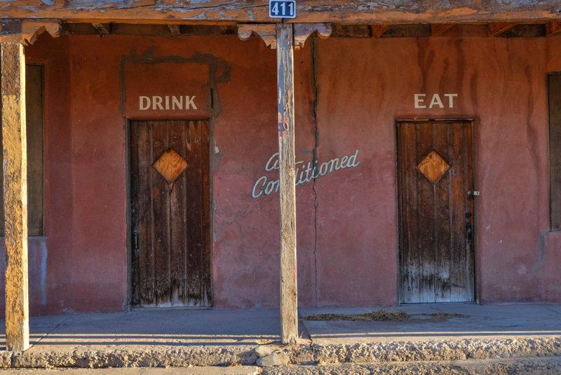
13-JAN-2014
No drinking, no eating, Carrizozo, New Mexico, 2014
This restaurant has shut down. It�s doors are locked, their windows boarded up. Water left its mark on its fa�ade, while a long crack runs through words that once proudly offered air conditioning. There has not been a drink or meal served here in quite a while, in spite of the signs over the twin doors. Yet the territorial architecture of this place speaks of the nature of New Mexico itself. Its portico creates a frame within a frame for my image, and the warmth of the evening light softens the harsh realities that stand before us.
13-JAN-2014
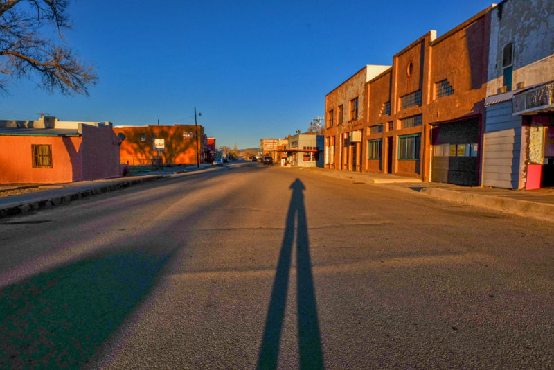
Shadow at sunset, Carrizozo, New Mexico, 2014
It is seldom that a photographer has an entire town to himself. But such was the case here, at least for the moment. I stood in the middle of Carrizozo�s main street as the setting sun elongated my own shadow, and made this image of myself stretching along blocks devoid of people, cars, or signs of life itself. This image speaks silently of a place that has seen better times.
13-JAN-2014
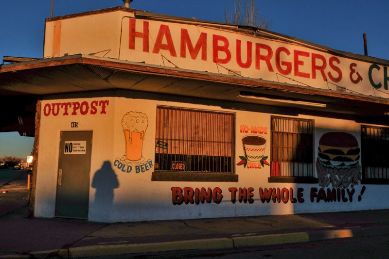
Closed, Carrizozo, New Mexico, 2014
The warmth of a setting sun contrasts to the grim evidence presented by still another of Carrizozo�s shuttered restaurants. This image conveys a sad irony � the beer is �cold,� the chili is �ho-made,� and there is a help wanted sign tucked in front of the window shade. Yet there is also a �closed� sign in that window, and a �for sale� sign behind this restaurant. My own shadow adds a punctuation point to this image � we were looking for a place to have dinner, but it would not be found here.
13-JAN-2014
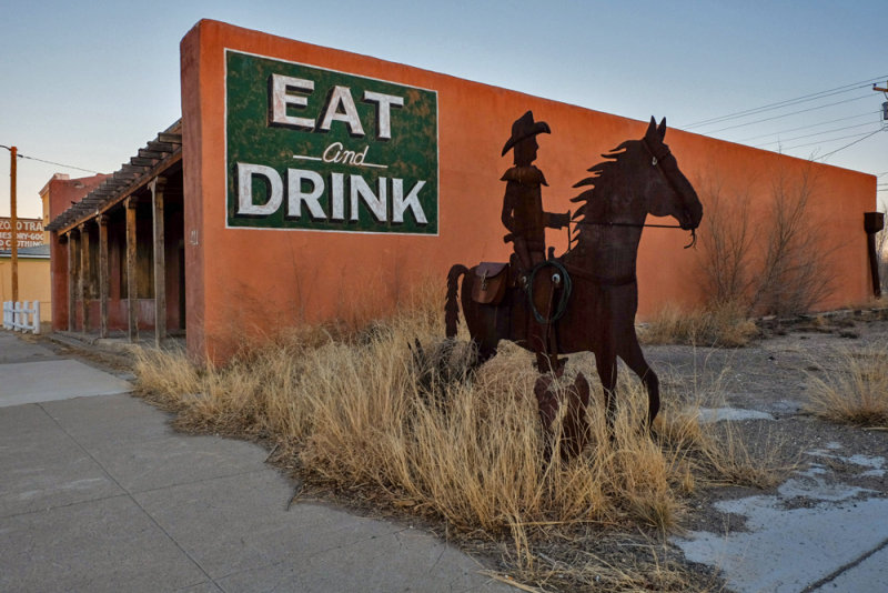
Riding the weeds, Carrizozo, New Mexico, 2014
As I walked along the length of Carrizozo�s main street, I encountered this rusting whimsical cowboy upon a horse trotting through knee high weeds bordering a vacant lot next to a restaurant known as �Eat and Drink.� The restaurant, like so much of this town, was out of business. This two dimensional sculpture is a work of public art, no doubt originally created to encourage tourists to stop and enjoy the flavor of the �Old West.� Yet the weeds, restaurant, and empty lot symbolize an all too familiar scenario along the rural back roads of the Southwest. There must be a very good reason for tourists to come to a place, and that reason has yet to appear here.
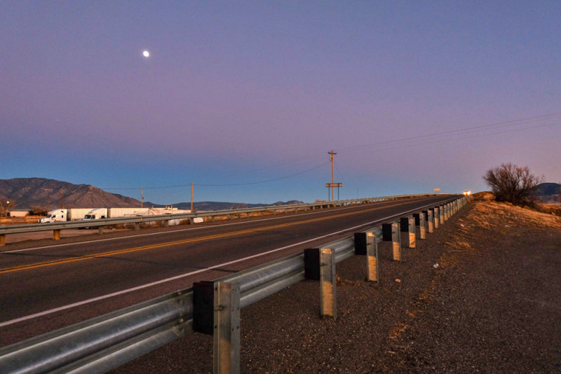
13-JAN-2014
Moonrise, Carrizozo, New Mexico, 2014
Two US highways cross each other on the outskirts of Carrizozo. As the moon came up, I stood alongside of one of them, and made this image. It evokes a sense of lonely, empty spaces � the lights of an oncoming car in the distance top the crest of a distant hill, while the metal guardrail draws it towards us. In the background, a smattering of telephone poles and two huge parked trucks are placed against a distant hill. It is a harsh land. Highways such as these may speed people from place to another, but in the process they often will bypass and isolate the small communities along the way.
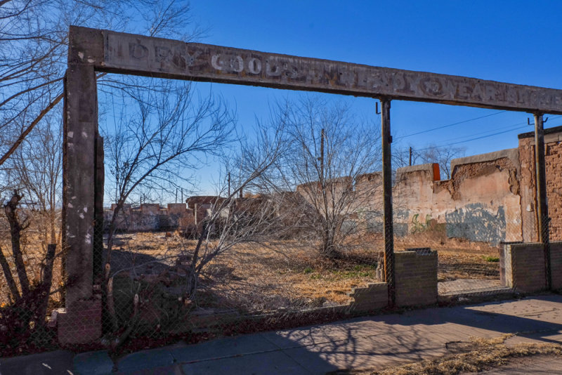
14-JAN-2014
The music has ended, Tularosa, New Mexico, 2014
Tularosa dates back to the Civil War era. I discovered the ruins of what I had thought was an old dry goods store along the main street of its historic district. After posting this image, a viewer added valuable additional context. He remembers it as a pickle packing warehouse, and later a place where local bands used to practice. But as the building fell apart, the music ended. The adobe walls surround an empty lot, filled with grasses and trees. Using a wideangle focal length, I placed the lot and the ruins within the surviving framework of the old facade. Its signage still survives as a ghostly remnant of the past.
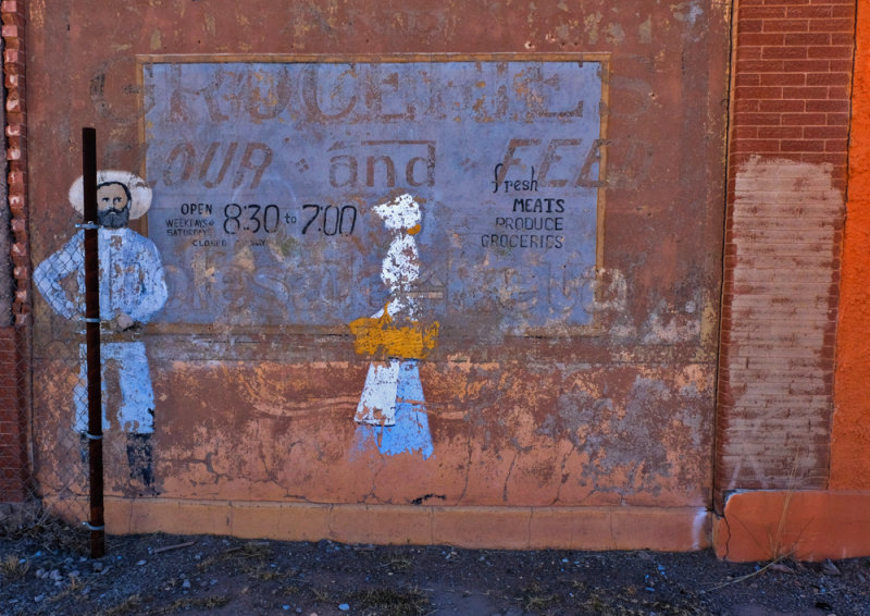
14-JAN-2014
Vanished grocery, Tularosa, New Mexico, 2014
Layers of signage tell the story of a grocery store that once occupied this building in Tularosa�s historic district. The figures of a farmer and a shopper symbolize the nature of the business, while the overlapping typography expresses the passage of time itself. The soft colors seem to gradually fade into the brick wall.
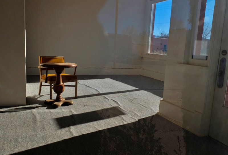
14-JAN-2014
The shop at the corner, Tularosa, New Mexico, 2014
A mismatched chair and table from different eras are the only occupants of this sun-drenched shop occupying the corner of one of Tularosa�s historic buildings. This image asks questions of its viewers: does the lack of furnishings mean the store is empty and for sale? Or does someone with minimal needs still use this space for business? In either case, the relationship of the furniture to the space is incongruous, and evokes a sense of the past, rather than the present.
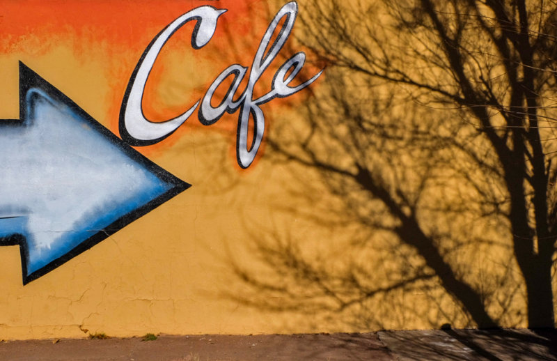
14-JAN-2014
Caf�, Tularosa, New Mexico, 2014
By framing only the point of an arrow and the name of the establishment, I abstract this image down its colorful essence. The arrow points to the word �Caf�,� which can only mean that we are being directed to the entrance of a caf� which is somewhere to the right. Yet there is no door visible, only the ephemeral shadow of a tree. The vivid orange and yellow wall incongruously emphasizes the mysteries within this image.
14-JAN-2014
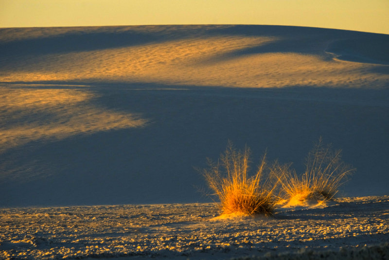
Dunes, White Sands National Monument, New Mexico, 2014
Rising from the heart of a mountain-ringed valley known as the Tularosa Basin is one of the world�s great natural wonders � the glistening dunes of the Whites Sands National Monument. I made this image of them at sunset, anchoring the image with two golden crowns of desert grasses. At this time of day, the interplay of light and shadow on the dunes is constantly changing as the sun drops below the mountains surrounding the Tularosa Basin.
14-JAN-2014
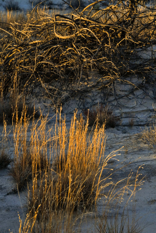
Survivors, White Sands National Monument, New Mexico, 2014
Only a few species of plants grow rapidly enough to survive burial in the shifting dunes driven by strong southwest winds. In this image, I pair two such survivors --a bush resembling a mass of snakes, and knee high desert grass. The setting sun illuminates both in warm light.
14-JAN-2014
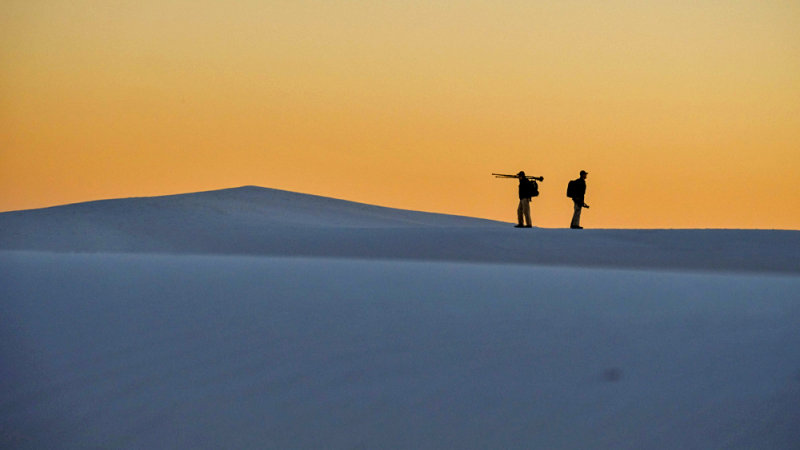
Farewell, White Sands National Monument, New Mexico, 2014
These dunes, made of gypsum, cover over 275 square miles of desert. A circular drive of packed sand leads visitors on an eight-mile loop. Many of those visitors are photographers � the light on the dunes, particularly at sunset, is magical. I made this image of two photographers on the crest of a dune. The sun has left the scene, and they bid each other farewell.
15-JAN-2014
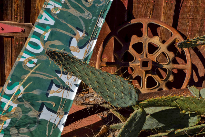
Still life, Orogrande, New Mexico, 2014
Three thousand people, many of them known as �Chicago Suckers,� were lured here in 1905 with promises of finding gold in the surrounding Jarilla Mountains. Plots of land were sold five and six times. The gold was virtually non-existent, and the prospectors vanished. Today, only 52 people live in Orogrande, a semi-ghost town literally in the middle of nowhere. The town�s most prominent surviving structure is an antique and rock shop, standing alongside of US 54, a lightly used highway connecting Alamogordo, New Mexico to El Paso, Texas. It was closed, and seemed likely to be up for sale. Rusted �antiques� such as pieces of ancient machinery and old advertising signs lay on the ground at its base. I found the Southwest�s most iconic plant, a Prickly Pear Cactus, thriving amidst the clutter, and made this emblematic still-life, symbolizing early 20th century New Mexico.
15-JAN-2014
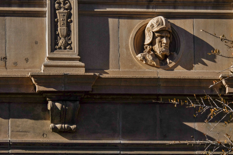
Conquistador, El Paso, Texas, 2014
Our �backroads tour� of the Southwest took a slight detour into America�s 19th largest city, El Paso Texas. We came to El Paso to photograph remnants of its colorful history, as well as to visit and photograph its historic Segundo Barrio neighborhood. The Spanish Conquistador Juan de Onate came to the banks of the Rio Grande in the late 16th century, and claimed the area for King Philip II of Spain. We can still see sculpted portraits of conquistadors circling the facade of El Paso�s former Cortez Hotel, which welcomed guests from 1926 to 1970. Today it is an office building.
15-JAN-2014
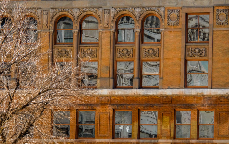
Viva Madero, Caples Building, El Paso, Texas, 2014
I moved in on the fa�ade of this historic office building to abstract it, and stress the magical reflections dancing upon its windows. The barren tree layers the image at left and intensifies the abstraction. The Caples building played a critical role in the history of neighboring Mexico. It was built in 1909 as a five-story structure. The top two floors (just above the cornice) were added in between 1915 and 1918. From its fifth floor windows, just below the cornice, viewers could easily see Juarez, Mexico, just across the Rio Grande from El Paso. In 1911, Mexico was in the midst of a revolution. Rebel forces fighting under Francisco Madero, Pancho Villa, Emiliano Zapata and Pascual Orozco were trying to end the 34-year dictatorial regime of Mexico�s president, Profirio Diaz.
Madero planned the pivotal battle of Juarez in the fifth floor offices of the virtually new Caples Building, perhaps behind the very windows at the bottom of this photograph. On April 7, 1911, the rebels poured 2,500 soldiers into Juarez, which was defended by only 700 government troops. Despite extensive bickering and dissension among their various generals, the rebels somehow managed to win the battle of Juarez after a month of squabbling and fighting, ultimately forcing President Diaz to flee into exile in France. The 38-year old Madero was elected president of Mexico in October, 1911. He was assassinated in February, 1913, during a military coup by General Victoriano Huerta.
15-JAN-2014
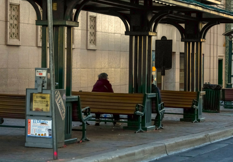
In transit, El Paso, Texas, 2014
An Art Deco bus stop shelter in downtown El Paso offers a time-tunnel glimpse of city life. The elegant bronzed support structure speaks of a day when waiting for a bus or trolley ride was an event, not a duty. In the background, we can see a panel of four small Art Deco windows. They are part of the S.H. Kress Building, which housed a now defunct five-and-ten-cent store from 1938 to 1997. In this image, only a few potential passengers patiently wait for a bus. As in many medium sized cities, residents now use personal automobiles to get around. A newspaper dispenser anchors the scene. It sells El Diario de El Paso � the city�s primary Spanish language newspaper with a circulation of over 100,000 people.
15-JAN-2014
Story telling Mural, El Segundo Barrio, El Paso, Texas, 2014
El Paso, Texas, and Juarez, Mexico, straddle the Rio Grande River. Because of the proximity to Mexico, eighty percent of El Paso�s residents are of Hispanic descent. El Segundo Barrio stands adjacent to the Rio Grande and the Mexican border. In the 19th century, it was an Anglo settlement. In the early 20th century, Mexican immigration into Texas began, and El Segundo Barrio was often the first stop. It is still among the poorest neighborhoods in the nation, yet for visitors, it offers a look at the essence of a culture. This mural, dominating the fa�ade of Sacred Heart Church, tells the story of these immigrants. Every day, people come here to rest, converse, or just sit in the setting sun. This image tells such a story.
15-JAN-2014
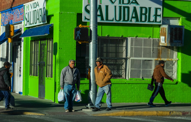
The crossing, El Segundo Barrio, El Paso, Texas, 2014
It is sunset in the barrio. The pace of life varies in this image from purposeful to relaxed. The startling green building, fully illuminated by a setting sun, sets the scene. It bears signage in Spanish, proclaiming �A healthy life.� Perhaps this is a clinic or a health counseling service? Its windows and doors are caged in steel. The light is also green, but not quite as green as the building behind it. And so life moves on in El Paso�s El Segundo Barrio.
15-JAN-2014
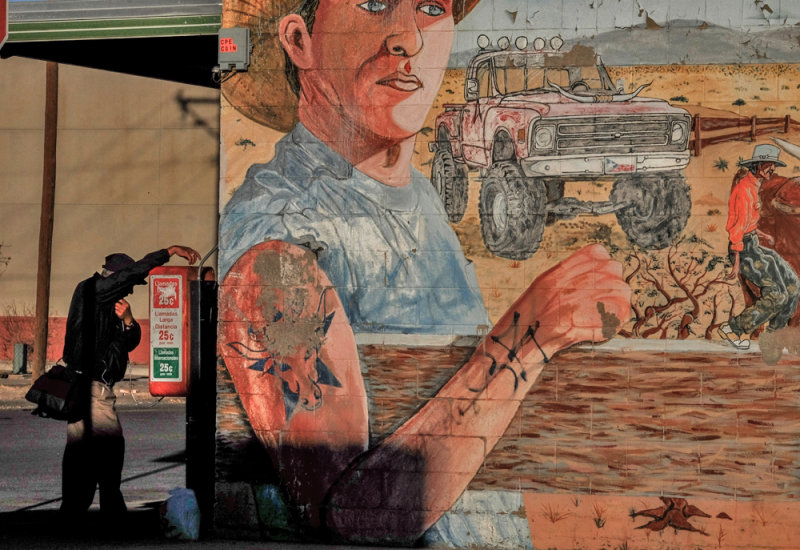
Phone call, El Segundo Barrio, El Paso, Texas, 2014
An agricultural mural dominates this photograph. It speaks of youth, farming, equipment, and promise. It plays against the body language of a man making a phone call. The pay phone he uses advertises international calls at 25 cents per minute in Spanish. Perhaps he speaks with family or friend in neighboring Mexico. One arm rests on top of the pay phone. It echoes the position of the arm of the young man in the mural. Only he is much larger in scale � a figure of promise, contrasting to the small abstracted figure behind him.
15-JAN-2014
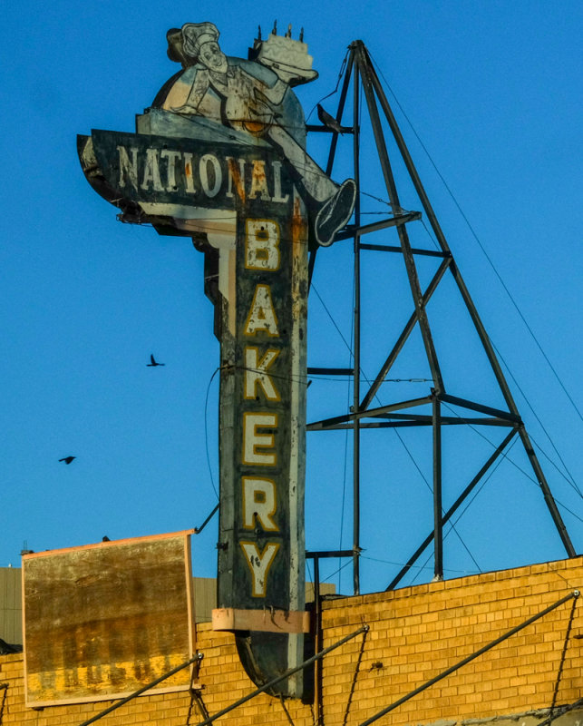
National Bakery, El Paso, Texas, 2014
I based this image on the rhythms created by the abundant triangles that flow through it. The sign�s support is triangular, and its struts create numerous triangles within triangles. Triangles even appear at the base of the image, as a series of canopy supports move across the frame. The design of the vintage sign itself speaks of El Paso history � generations of residents have shopped here over the years. I assume that the sign is illuminated at night, not only proclaiming the name of the business in lights, but also its product � a bakery chef holds a birthday cake, marked by four candles. To complete the story, a bird has taken up temporary residence just under the cake, while other birds fly past the sign.
15-JAN-2014
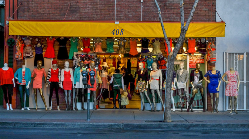
Gathering of mannequins, El Paso, Texas, 2014
A rank of fifteen mannequins stand behind a pair of parking meters and a small tree in front of a clothing store in downtown El Paso. None of them move. The only subject my camera stops in time are the pair of shoppers pausing to examine some clothing in the doorway that splits the line of mannequins into two sections. The image is incongruous � not only is the sheer mass of mannequins unusual, a pair at each end of the line have lost their heads, while all of the legs are either silver and gold.
15-JAN-2014
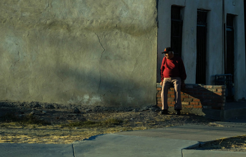
Evening in the El Segundo Barrio, El Paso, Texas, 2014
This man was bracing himself against a small brick wall. He looks into the distance, while the evening shadows begin to gather around him. I placed him on the right hand side of the frame, so that I could contrast his small form against the scale of the massive wall that dominates the scene. The setting sun warms the entire image, making what would ordinarily seem to be a bleak street corner into a theatrical stage set.
15-JAN-2014
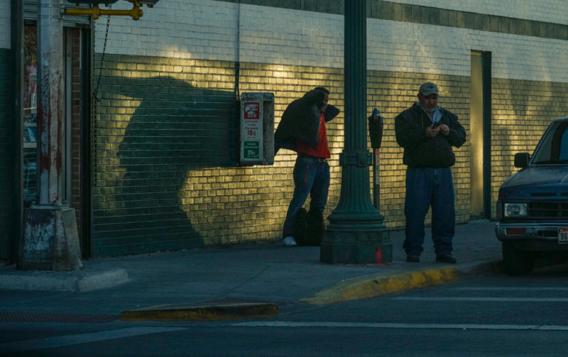
Street life, El Segundo Barrio, El Paso, Texas, 2014
I was watching for the play of shadow as much as I was studying the actions of these people. The action here is very simple. A man is checking his cell phone on a street corner, while a man waiting behind him is putting on his jacket as evening arrives. The low angle of the sun has extended the shadow of that man�s arm as he grapples with the jacket, creating an incongruously large shadow on the golden bricks behind him.
16-JAN-2014
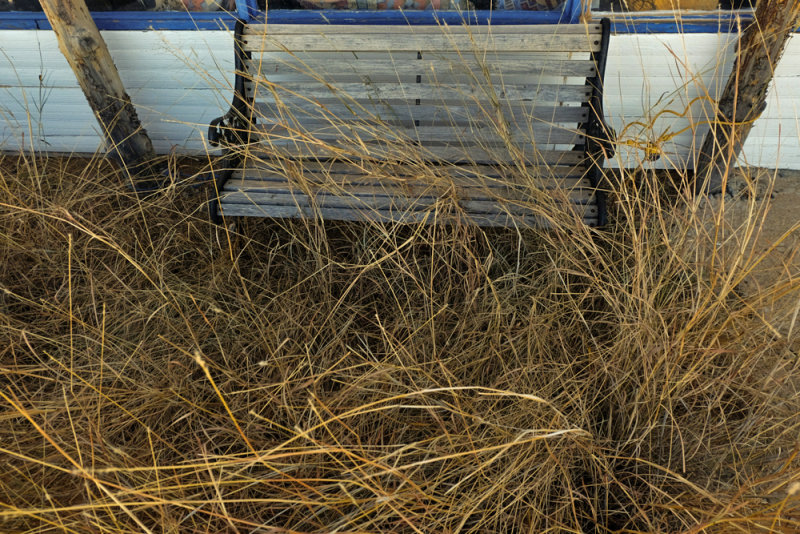
Waiting in the weeds, Hachita, New Mexico, 2014
Hachita is a small village west of El Paso � at the turn of the 20th century, it was a railroad stop for the precious metal mines in the area. When the mines played out, the town withered away. Today it has only a few residents. I found this bench chained to the town�s abandoned restaurant. It is nearly obscured by the weeds that have claimed the area.
16-JAN-2014
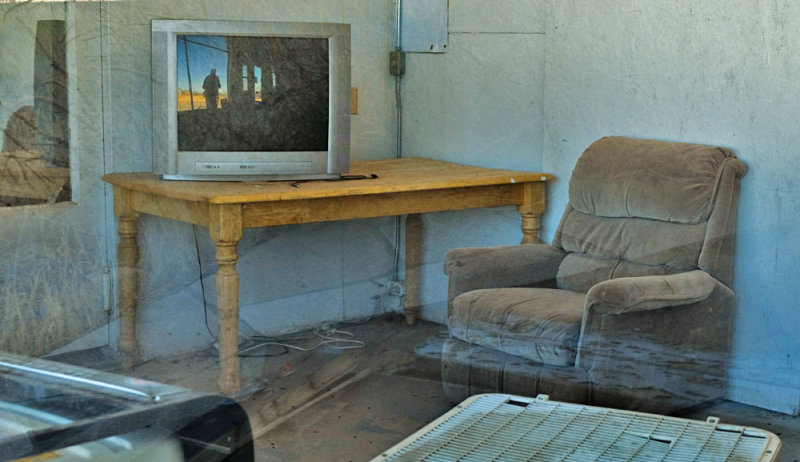
Ghostly office, Hachita, New Mexico, 2014
I made this ghostly image through the office window of an abandoned gas station in the semi-ghost town of Hachita. Reflections in this window cause the chair to seem to be drifting in space, while an array of faint weeds float within the wall at left. The abandoned TV seems to have been left on, however it is only a reflection of the photographer making this image. That reflection is also laced with hazy weeds.
16-JAN-2014
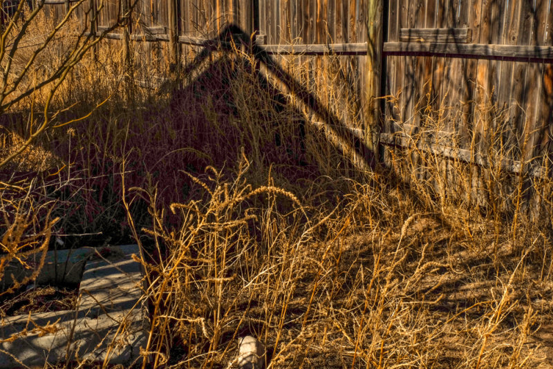
Ravages of time, Hachita, New Mexico, 2014
The shadow of a disintegrating house rises from dead weeds to imprint itself on a sagging fence. This image does not attempt to show what this semi-ghost town looks like � instead it uses abstraction to symbolize the ravages of time. I use Geometry, texture, color and shadow tell the story.
16-JAN-2014
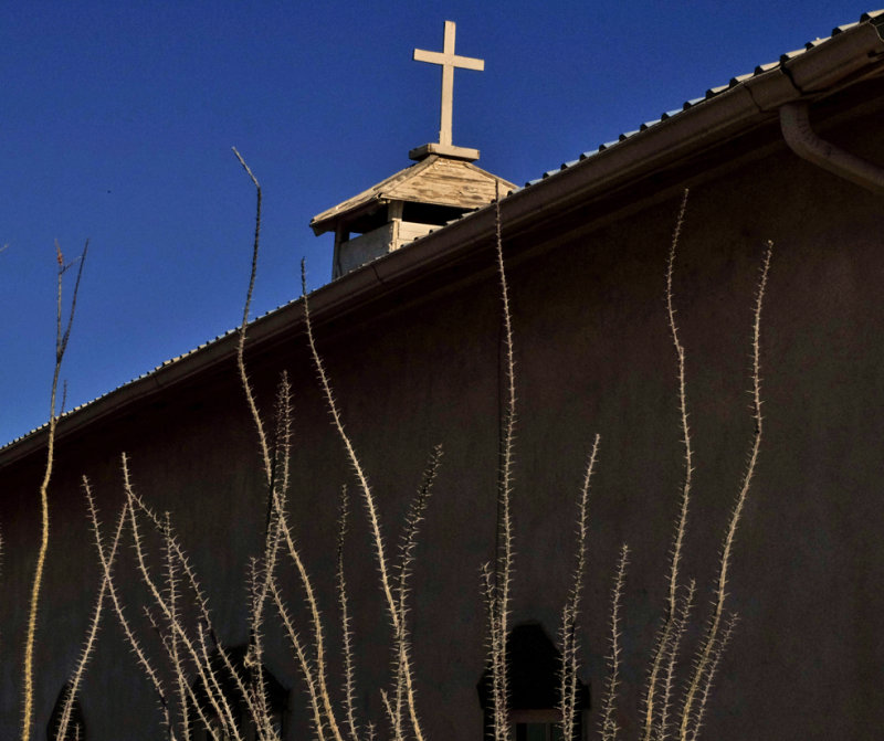
From church to gallery, Rodeo, New Mexico, 2014
This church building was once a saloon, and is now a well-regarded art gallery in this small town along Old US Route 80. The light was harsh and directly overhead when I made this image. I used the high contrast shadows on the gallery wall to my advantage by placing a layer of Ocotillo plants before them. The diagonal roofline draws the from the upper right hand corner into the image, while the slanting roof of the old cupola on top of the building repeats the diagonal.
16-JAN-2014
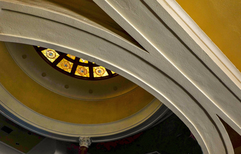
Train station, Douglas, Arizona, 2014
Douglas was founded in 1905 as a smelter town, treating the copper ore coming out of nearby Bisbee, Arizona. Douglas was the only town in Arizona that had railroad tracks leaving town in four directions. The El Paso and Southwestern Railroad transported the smelted copper to manufacturers in the east. Its passenger depot, built in 1913, featured a dome topped with stained glass. Passenger service ended in Douglas over fifty years ago, and the depot gradually deteriorated. In order to save it, the city moved its police department headquarters into the building. The former depot has been beautifully restored and still open to the public. I made this abstracted view of the inside of the old depot dome by shooting upwards with a wideangle lens to stress the powerful curves leading the eye towards the stained glass. It was the first picture I�ve ever made from inside of a police headquarters.
16-JAN-2014
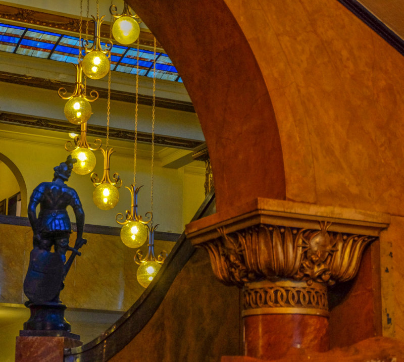
Entrance, Gadsden Hotel, Douglas, Arizona, 2014
The Gadsden Hotel is the stuff of legend and history. It opened in 1907, before Arizona became a state. It later was damaged by fire, reopening in 1929 as an early 20th Century Art Nouveau showplace. I made this image from its entrance. The ornate supporting column at right is clad in gold leaf, a classical statue looms ahead of us, while the curving entrance opening echoes one of the lobby�s curving chandeliers.
16-JAN-2014
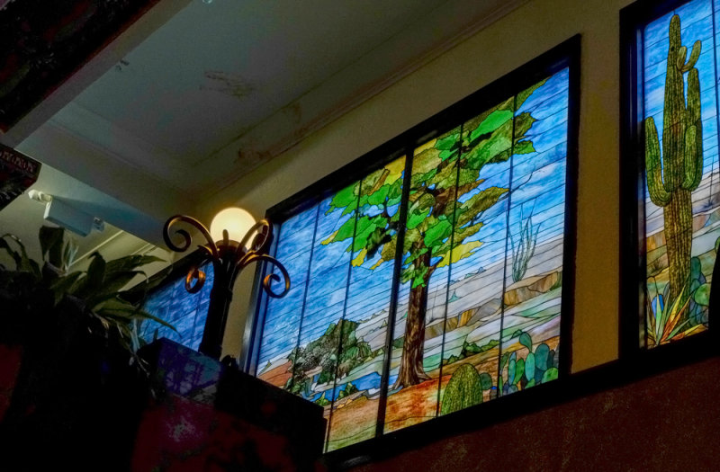
Tiffany mural, Gadsden Hotel, Douglas, Arizona, 2014
The Gadsden�s lobby is known for its spectacular 42-foot wide authentic Tiffany stained glass mural at the top of a marble staircase, featuring western scenes. I include only one of its five panels in this image, along with parts of two others. I layer the scene with one of the two lamps that crown the staircase.
16-JAN-2014
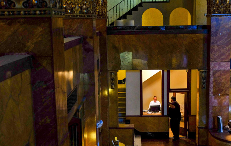
Managerial moment, Gadsden Hotel, Douglas, Arizona, 2014
The Gadsden is currently under restoration by new management. Amidst antique splendor, a modern-day manager deals with the challenges of restoring an old hotel. I was shooting the hotel�s marble lobby from a second story balcony when I noticed him working on a computer in his office. An employee stopped by to chat with him through a partially open door. The overall image contrasts decorative glittering slabs, columns, and arches -- all vestiges of the past � to a brilliantly illuminated yet spartanly furnished contemporary office.
16-JAN-2014
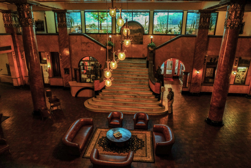
Lobby, Gadsden Hotel, Douglas, Arizona, 2014
The Gadsden�s lobby is built around its original 1907 Italian marble staircase, surrounded by four Italian marble columns each capped with 14k gold leaf worth $20,000 in 1929. The entire 42-foot Tiffany stained glass mural can be seen at the top of the stairs. This space was once known as the �living room� for the cattlemen, ranchers, miners, and businessmen in the Arizona Territory. While I was photographing the lobby from a second floor balcony, I noticed my photographic colleague Tim May admiring the scene downstairs, and used him to lend a sense of scale to this 24mm wideangle image. I saw very few current guests during our shoot in this hotel, but I could easily imagine those cattle barons and mining magnates sitting here trading stories and doing business over a few cigars and some bourbon. The hotel, said to be haunted, keeps a logbook for people to record experiences with �spiritual turbulence.�
17-JAN-2014
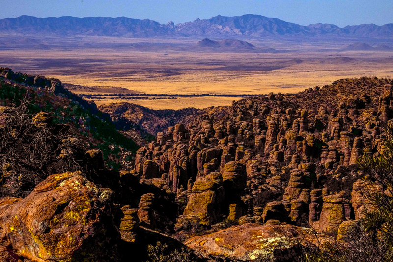
Apache stronghold, Chiricahua National Monument, Arizona, 2014
The Chiricahua Apache, who once camped among these pinnacles, called them the �standing up rocks� because it was a place like no other � a magical kingdom of natural formations formed 27 million years ago when the Turkey Creek Volcano erupted, spewing ash over a thousand square miles. The heated ash melted together, forming layers of Rhyolite. Eons of weathering and erosion cracked these rocks into strange sculptures, herding them into a mass arrayed along the slope of an isolated mountain rising above a grassland sea. They comprise the most striking feature of this isolated national monument, which is located about two hours east of Tucson. In this landscape image, I offer a layered view of these formations. Huge boulders lead us to the sculpted rocks, while winter grass leads the eye to the distant mountains at the top of the frame.
17-JAN-2014
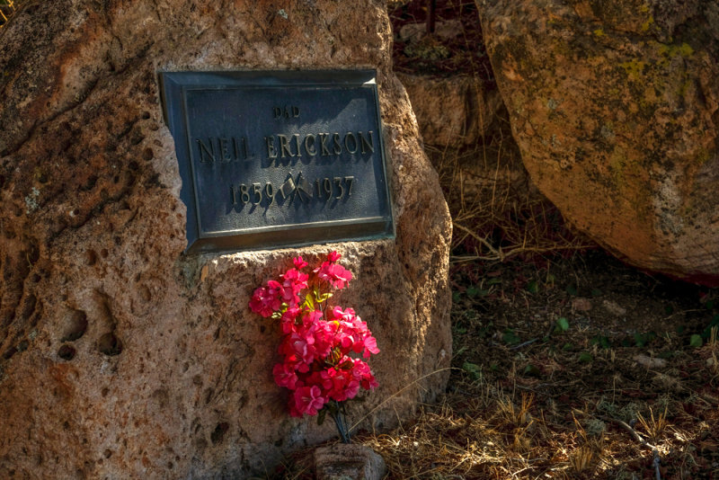
Erickson Pioneer Cemetery, Chiricahua National Monument, Arizona, 2014
Swedish immigrants Neil and Emma Erickson built a homestead here in 1888. By the 1920�s, their daughter Lillian, along with her husband, Ed Riggs, turned the homestead into a guest ranch, drawing visitors to this wonderland of rocks. Armed with photographs, they lobbied for the area�s protection, which came when President Calvin Coolidge created the Chiricahua National Monument in 1924. Today, members of the Erickson family rest below large boulders in a tiny cemetery near the entrance station for the Monument. I built this image around a splash of light on a spray of flowers, left here in memory of the pioneer family�s founding father, Neil Erickson.
17-JAN-2014
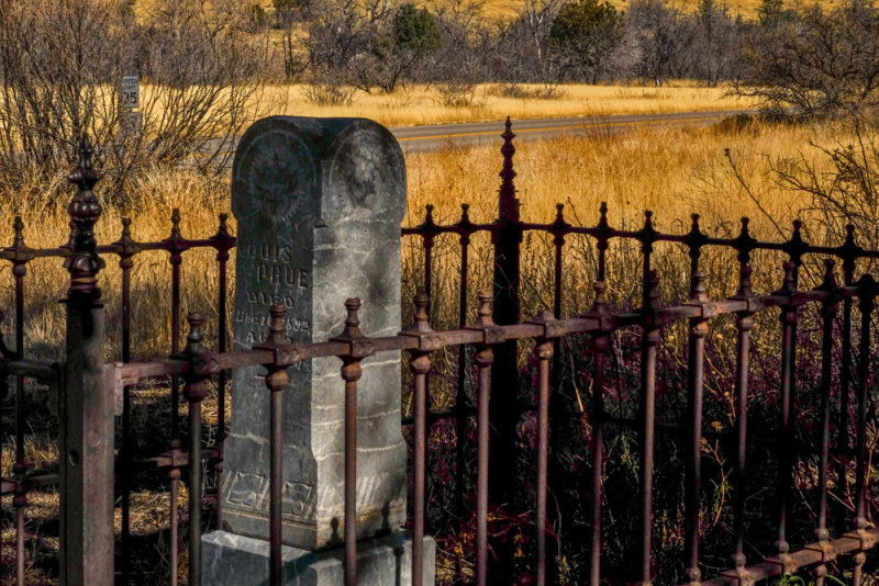
First settler, Chiricahua National Monument, Arizona, 2014
Louis Prue was the nearest neighbor of the Erickson family. A former soldier under the command of General George Crook, Prue settled in the area in 1879, reportedly the first settler (aside from the Chiricahua Apaches) in what is now the Chiricahua National Monument. He was the first explorer of this area, and he established a cattle ranch here a full nine years before the Erickson�s arrived from Sweden. On his ranch, he built a stone blockhouse for protection in case of an attack by Geronimo and his Chiricahua Apaches that roamed this area. Before falling from a horse and dying in 1892, Prue asked Neil and Emma Erickson if he could be buried on their homestead, where �he could see his cattle passing on the way to water.� The Erickson family honored his wish. He is buried in a plot surrounded by a rusting original Victorian era fence. A shadowy stone marks his grave, only a few yards away from the Erickson family cemetery. I made this image from this spot to stress the fields of winter grass that stretch into the background. It is a perfect setting for a rancher and explorer who once fought on the American frontier.
17-JAN-2014
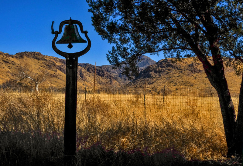
School Bell, El Dorado School House, Chiricahua National Monument, Arizona, 2014
The rural schoolhouse that formerly served this area has long since been abandoned. Yet its old bell still remains standing, a reminder of another era in American history. I was able to photograph it in silhouette, its upright handle echoing the upwards thrust of a nearby tree. Outlined against the golden winter grasses and a clear deep blue sky, I could almost hear it ring. This image offers an appropriate close to our weeklong exploration along the historic back roads winding through a part of the American Southwest.