photo sharing and upload picture albums photo forums search pictures popular photos photography help login
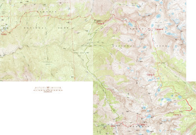
Joe Petolino | profile | all galleries >> California >> High Sierra Backpack, 2012 tree view | thumbnails | slideshow | map

High Sierra Backpack, 2012

Mineral King to Crescent Meadow, in Sequoia National Park.

Plant and bird IDs are from The Laws Field Guide to the Sierra Nevada.

As always, your comments are appreciated. Just click the yellow comment link in the lower-left corner of the page.
Jim at the trailhead. g4/89/612589/3/145351169.2zhw0i6g.jpg g4/89/612589/3/145351172.X64myAsj.jpg g4/89/612589/3/145351173.xXfs4quK.jpg Sooty Grouse
g4/89/612589/3/145351171.dllxcPmI.jpg Lower Monarch Lake Upper Monarch Lake g4/89/612589/3/145351175.KUL0hU9k.jpg Benjamin and Ken
Rainer g4/89/612589/3/145351178.8xEI5WmB.jpg g4/89/612589/3/145351179.KtsvNtCh.jpg g4/89/612589/3/145351180.6jypyo0u.jpg Mineral Peak
g4/89/612589/3/145351182.mTdKmY3Y.jpg Setting sunlight on glacier-polished granite g4/89/612589/3/145351184.ySveBxh8.jpg g4/89/612589/3/145351185.mmSCezGy.jpg Starting up Sawtooth Pass
g4/89/612589/3/145351187.ML2mKoNi.jpg Don Chetan Jim Looking west from Sawtooth Pass
Columbine Lake from Sawtooth Pass Columbine Lake The trail down to Lost Canyon g4/89/612589/3/145351195.T8EC3pIb.jpg g4/89/612589/3/145351196.SZlGhq1Y.jpg
g4/89/612589/3/145351197.pJgCKENf.jpg Fun with lasers g4/89/612589/3/145351199.7tDkerfN.jpg g4/89/612589/3/145351201.uj912Rej.jpg Camp at Little Five Lakes
g4/89/612589/3/145351203.whGehycl.jpg g4/89/612589/3/145351204.lSj8M251.jpg Big Arroyo Patrol Cabin g4/89/612589/3/145351206.fu2TcnUT.jpg g4/89/612589/3/145351207.V2JRSwIX.jpg
g4/89/612589/3/145351208.ETAvpfnA.jpg Grazing in Big Arroyo g4/89/612589/3/145351210.gBFTgqps.jpg g4/89/612589/3/145351211.YBHdNIJ0.jpg Nine Lake Basin
g4/89/612589/3/145351213.BbAeYw4S.jpg Chetan and John g4/89/612589/3/145351216.fO5Eis4s.jpg g4/89/612589/3/145351254.fnHiu03u.jpg g4/89/612589/3/145351217.piR8E9bh.jpg
g4/89/612589/3/145351218.39DmpDc7.jpg Nine Lake Basin from Kaweah Gap g4/89/612589/3/145351220.wNHaOxYN.jpg Precipice Lake g4/89/612589/3/145351224.3bJxcIyk.jpg
g4/89/612589/3/145351223.IxJSmmZc.jpg g4/89/612589/3/145351225.rKA0SHCp.jpg g4/89/612589/3/145351226.ilAz3iT1.jpg g4/89/612589/3/145351227.3qvcjruz.jpg Mountain Gartersnake
g4/89/612589/3/145351230.NKdyiHwQ.jpg Upper Hamilton Lake. g4/89/612589/3/145351193.TMJ27WC5.jpg Rock Fringe g4/89/612589/3/145351221.ZZZAWswn.jpg
Fireweed g4/89/612589/3/145351235.8aiinVaD.jpg Pinedrops Alpine Gentian Silk Tassel Bush
Explorer's Gentian Paintbrush g4/89/612589/3/145351239.9pEcvtSd.jpg Sneezeweed g4/89/612589/3/145351233.OAShXPud.jpg
g4/89/612589/3/145351234.1mAG0rPs.jpg g4/89/612589/3/145351236.TnjUErlm.jpg Mushroom Cloud Lone Pine Creek The old Lone Pine Creek footbridge
Jim at Bearpaw High Sierra Camp g4/89/612589/3/145351242.Sh3MbZIc.jpg g4/89/612589/3/145351243.uLuVr79K.jpg g4/89/612589/3/145351245.sXNtLl5F.jpg g4/89/612589/3/145351246.4YXEoWb9.jpg
Afternoon thunderstorm g4/89/612589/3/145351248.Sh0UdXMT.jpg Benjamin, John, Ken, and Rainer Joe at the end USGS maps for the hike.