


|
|
|
|
|
|
| |
| 08-DEC-2007 | |
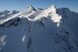
The view looks to the SW.
Napeequa Pk: 48° 06' 14"N, 120° 58' 19"W
Topographic Map
| Full EXIF Info | |
| Date/Time | 08-Dec-2007 09:15:25 |
| Make | Canon |
| Model | Canon EOS DIGITAL REBEL XTi |
| Flash Used | No |
| Focal Length | 17 mm |
| Exposure Time | 1/500 sec |
| Aperture | f/8 |
| ISO Equivalent | 200 |
| Exposure Bias | |
| White Balance | |
| Metering Mode | average (1) |
| JPEG Quality | |
| Exposure Program | aperture priority (3) |
| Focus Distance | |
Copyright 2002-2023, John H. Scurlock, Photographer/Pilot