photo sharing and upload picture albums photo forums search pictures popular photos photography help login
John Scurlock | all galleries >> Galleries >> Glaciers & Mountains Of Southern Washington, Oregon, & Northern California > Burnt Lava Flow From The East
(MF_2_011913-115-3.jpg)
previous | next
19-JAN-2013

Burnt Lava Flow From The East
(MF_2_011913-115-3.jpg)

Modoc National Forest

view map

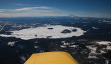
Burnt Lava Flow Geological Area
Modoc National Forest


Burnt Lava Flow lies on the south flank of the Medicine Lake Volcano/Mt. Hoffman.
Note Mt. Shasta at R distance.
Flight conducted in collaboration with Steph Abegg, photographer & climber.


other sizes: small medium large original auto
share