Dave Beedon
|
all galleries
>>
Photography
>>
Rephotography, or Once Is Not Enough
>>
Rephotography: Boulder on a Mesa
> Looking east from the Goose Neck Viewpoint
previous
|
next
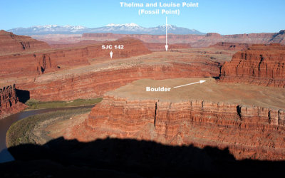
Looking east from the Goose Neck Viewpoint
Near Moab, Utah
view map
"SJC 142" is
San Juan County Route 142, often called "Shafer Trail"
.
Thelma and Louise Point
is an unofficial name for Fossil Point.
Here's a
view of the Goose Neck Viewpoint from the boulder
.
.
other sizes:
small
medium
original
auto
previous
|
next
All images are copyright 1966 - 2023 by Dave Beedon (davebeedon AT comcast DOT net).
share
Type your message and click Add Comment
It is best to
login
or
register
first but you may post as a guest.
Enter an optional name and contact email address.
Name
Name
Email
help
private comment
Type your message and click Add Comment
It is best to
login
or
register
first but you may post as a guest.
Enter an optional name and contact email address.
Name
Name
Email
help
private comment