


|
|
|
|
|
|
| |
| 20-MAR-2007 | Dave Beedon |
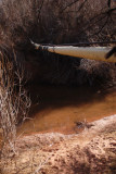
This is where the two branches of Jackson's Trail meet. I have come the long way (from
the right). The shorter approach---more difficult to follow---is from straight ahead,
in the dark area left of the pipeline. Both routes involve a fording of the creek,
which was quite shallow. This site is at the center of this WikiMapia aerial view:
http://www.wikimapia.org/#lat=38.532624&lon=-109.602968&z=17&l=0&m=a&v=2 .
.
All images are copyright 1966 - 2023 by Dave Beedon (davebeedon AT comcast DOT net).
| Dave Beedon | 24-Mar-2008 04:26 | |
| The Third Side | 24-Mar-2008 02:06 | |
| Guest | 08-Nov-2007 05:33 | |
| Jason Anderson | 21-Aug-2007 11:32 | |