photo sharing and upload picture albums photo forums search pictures popular photos photography help login
Dave Beedon | all galleries >> Places >> Utah >> Moab (environs) >> Poison Spider Mesa: Loop Through the Fins > Canyon as seen from the road
previous | next
15-MAR-2007 Dave Beedon

Canyon as seen from the road

Potash Road (near Moab, Utah)

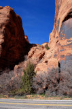
This view looks west into the canyon between two fins. An informal path enters the bushes at left and
leads into boulders and rock slabs. Last year I explored on the right side almost to the skyline. This
year I discovered a better route in the shadow on the left. What landscape delights lie out of sight?

This is at the center of this WikiMapia aerial photo:
http://www.wikimapia.org/#y=38540953&x=-109602077&z=18&l=0&m=a&v=2 .

.

Nikon D80 ,Nikkor 20mm f/2.8 AF
1/250s f/9.0 at 20.0mm iso100 full exif

other sizes: small medium large auto
share
Dave Beedon23-Jun-2007 01:23
Actually the distances were not significant, but the feeling of being away from civilzation was profound.
Jason Anderson23-Jun-2007 01:20
Wow, looking at the map I can see you've logged some serious mileage. Enough to know that cliffs, crevasses and gorges lie out of sight.
1moremile01-Apr-2007 22:57
Great colors. Will you be making your own map system here?
Type your message and click Add Comment
It is best to login or register first but you may post as a guest.
Enter an optional name and contact email address. Name
Name Email
help private comment