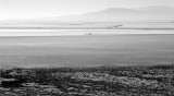
Just above the center of the photo is the eastern end of the salt flats access road. A
semi-trailer rig and some cars are parked there. The light area surrounding the end of the
road is shallow water sitting on the salt flats. Below the road is a large grayish area of
salt/mud. The dark speckles at bottom are low bushes on the edge of the playa. The thin line
just above the access road is a dike. Above the dike is Interstate 70 with vehicles at
center. Evaporation ponds used by Intrepid Potash extend for miles beyond the interstate.
The Bonneville Speedway (no markings) runs parallel to and below the dike.
This view to the south was taken from low on the the east flank of Tetzlaff
Peak. The reverse view from the end of the salt flats access road looks
like this: http://www.pbase.com/listorama/image/67475365 .
.