


|
|
|
|
|
|
| |
| 17-APR-2006 | Dave Beedon |
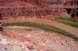
The Colorado River is flowing from right to left, curving around the north end of the Goose
Neck. Across the river, Shafer Trail runs along the light-colored layer of rock near the top
of the photo. My descent, which has just begun, will end up at the boulders at lower right.
On another hike I explored the shadowy alcove in the cliff at upper right.
.
| Full EXIF Info | |
| Date/Time | 17-Apr-2006 12:40:32 |
| Make | Nikon |
| Model | D100 |
| Flash Used | No |
| Focal Length | 20 mm |
| Exposure Time | 1/200 sec |
| Aperture | f/14 |
| ISO Equivalent | |
| Exposure Bias | 0.67 |
| White Balance | (9) |
| Metering Mode | matrix (5) |
| JPEG Quality | (6) |
| Exposure Program | manual (1) |
| Focus Distance | |
All images are copyright 1966 - 2023 by Dave Beedon (davebeedon AT comcast DOT net).