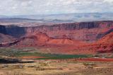
The red hills at center are called "The Red Hills" on the "Classic Moab, Utah Trails Recreation Topo
Map" published by Latitude 40 Degrees, Inc. Castle Valley Road curves to the right to pass over the
hills on its way to Highway 128, which runs parallel to the dark cliff behind the hills (and next to
the Colorado River). Another person who has photographed those red hills and this valley is Dan Dunn.
This view is the opposite of the first look I had at Round
Mountain: http://www.pbase.com/listorama/image/53212119 .
.