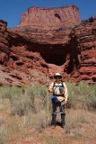
In this view looking northeast, the levels of consciousness are:
1) Amphitheater floor (grass, sagebrush, and cow pies);
2) Head of the explorer (non-functioning area due to its
being overwhelmed by the scenery);
3) Shelf ("level" area just above the big shadow; location
of San Juan County Road 142);
4) Mesa at top (location of Dead Horse Point State Park).
San Juan County Road 142 (casually but incorrectly called �Shafer Trail�), curves around this amphitheater.
This image would not have been possible without the level and
conscious support of my personal assistant, Joe Tripod.
|