


|
|
|
|
|
|
| |
| 13-APR-2006 | Dave Beedon |
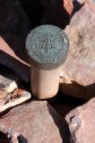
This marker identifies the intersection of four survey "sections" in the
land survey scheme used in the West. The stamped data is translated so:
Township 27 South, Range 20 East, at the corner of sections 7, 8,
18, and 17. Don't you feel better knowing that?
.
All images are copyright 1966 - 2023 by Dave Beedon (davebeedon AT comcast DOT net).
| MacPurity | 05-Jan-2007 21:17 | |