


|
|
|
|
|
|
| |
| 10 Jul 2004 | Dave Beedon |
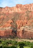
Looking southwest across the valley at a stream canyon below Porcupine Rim. Elevation of the
stream is 4400 feet; elevation of the rim is about 6000 ft; vertical distance between the
two is 1600 ft (480m). The next photo is a close-up of the cliff at bottom right.
Topographic map: USGS Big Bend, UT (1:24,000).
All images are copyright 1966 - 2023 by Dave Beedon (davebeedon AT comcast DOT net).