


|
|
|
|
|
|
| |
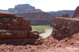
| 9 Jul 2004 | Dave Beedon |
Looking southwest at the Colorado River, which is flowing from bottom to top. Here the river flows around the north
end of a formation called The Gooseneck (not to be confused with Goosenecks State Park). Straight ahead, a stream
flows out of Shafer Canyon into the river. Several miles downstream is The Confluence, the point where the Green River
flows into the Colorado. Shafer Trail continues westward on the sunny, tilted plateau at right. The bottom of this
picture is close to the edge of a frightening drop-off into a stream canyon.
All images are copyright 1966 - 2023 by Dave Beedon (davebeedon AT comcast DOT net).