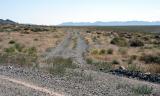
Looking north at the side road that leads to Floating Island, which is off to the right. The road goes straight for a while, then makes a long, gentle curve to the right, crossing three dry stream channels. (One of the channels required a slow, careful crossing to avoid "hitting bottom" with a bumper. On one occasion I had to use a shovel to create a more car-friendly gradient) At the end of the long curve is a causeway that connects the land mass of the Silver Island Mountains to Floating Island
|