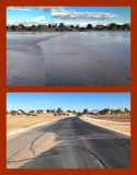
Rancho El Dorado Parkway, a loop road in the Rancho El Dorado housing area of Maricopa, crosses a wide wash without benefit of a bridge or berm. Normally it looks like the scene in the lower image. The dry view was captured nine days after the wet one, which explains the presence of sand in the road.
When it rains, much of the neighborhood drainage ends up here, as seen in the upper picture. The water on the road is about two inches (5 cm) deep. When flooded, the road is closed. Water flows from right to left (northward).
Both photos look eastward along the northern crossing of the wash. I took both photos in January 2016 while standing in the road.
The bottom of the wash is about ten feet (3 m) below the level of the housing area. That elevation change is one of only two significant cycling challenges in Maricopa. I use this road when passing through this housing area, as it is the only through route.
|