


|
|
|
|
|
|
| Juan Rojas | profile | all galleries >> Aire libre >> BTT Bicicleta Todo Terreno / Mountain Bike MTB >> BTT: TransAndalus con Google Earth | tree view | thumbnails | slideshow |
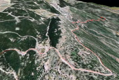
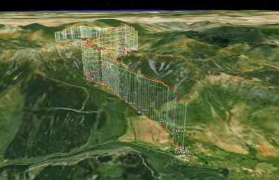
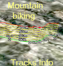
La técnica de documentación de recorridos por la naturaleza denominada
DARGE
dibuja el camino seguido sobre las
vistas tridimensionales
del terreno que ofrece
Google Earth
y le ańade marcas de kilómetros, tiempos de paso, pendientes, cotas, etc.
The documentation technique for nature routes named
DARGE
draws the followed path on the 3D views
of the terrain showed by Google Earth
adding marks of kilometers, time, slope, speed, etc.
El movimiento de las vistas sobre el terreno puede hacerse
simulando el vuelo de un avión
por encima del recorrido realizado.
Para ir a la página web DARGE que contiene rutas a pié y en bicicleta de montańa documentadas con esta técnica
HAGA CLICK AQUÍ.
Para pasar a ver directamente en Google Earth la documentación de las rutas correspondiente a estas fotos use los siguientes enlaces:
San Telmo - Calańas
Calańas - Camping Giralda
Camping Giralda - Valencina
The movement of the views on the terrain can be done
simulating the fly of a plane over the track.
To go to DARGE web page with many walking and mountain bike routes documented on this way
PRESS HERE
You can see directly on Google Earth the documentation of the routes related with the photos in this page using the following links:
San Telmo - Calańas
Calańas - Camping Giralda
Camping Giralda - Valencina
:: TransAndalus: Calańas - Valverde - Trigueros :: |
:: TransAndalus: San Telmo - Calańas :: |
:: TransAndalus: Trigueros - Moguer - Almonte - Villamanrique :: |
 DARGE: Documentacion automatizada de rutas con Google Earth |
 DARGE: Documentacion automatizada de rutas con Google Earth |
 DARGE: Documentación automatizada de rutas con Google Earth |
| comment | share |