


|
|
|
|
|
|
| |
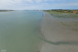
Eureka - Humboldt County - California
This image is taken from a bridge along California State Highway 255. This is a look at where Humboldt Bay connects to Arcata Bay.
The strip of land ahead and to my right is a thin peninsula leading to the north end of the jetty opening to Humboldt Bay. The Pacific Ocean is less than a mile to my right.
Directly ahead is the large Louisiana-Pacific Lumber Company operation - the last of the huge lumber companies that dominated this land. The town of Eureka is to my left.
Two islands sit between downtown and this location. A corner of Indian Island can be seen in the upper left. It is a mostly wild sanctuary with no roads or land access.
Just east of Indian Island is the smaller Woodley Island which is home to the regional office of the National weather Service,
a large marina which provides berthing to much of the areas fishing and crabbing fleet as well as pleasure craft, and one of my favorite local eateries - The Marina Cafe.
Just across from the marina is the 'Old Town' section of Eureka.
This particular morning saw me hiking along Arcata Bay for several hours and this is the one brief moment that there was sunshine.
Almost as soon as I made this capture - the clouds began closing in and the day became cloudy once again.
Copyright © by Stephen Phillips Photography. Please respect these rights. Do not copy or use without permission.