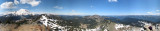
Mt. Rainier (elevation 14411 feet) is near the left side. Near the right side is a 180-degree turn on the road to Sunrise. Photos taken from Dege Peak (elevation 7006 feet), the top of which is visible in the foreground, on the left and right sides of the panorama. The panorama covers about 270 degrees. The photos for the remaining 90 degrees are excluded; their exposures do not match because of clouds. For a sample of what is missing, see http://www.pbase.com/ralph_s/image/81316777
The pano stitching software used is not powerful, so if you look closely, you can see stitching errors.
The "original" size contains much more detail than the "large" size (5690 pixels wide versus 800 pixels).
_________________________________________________________________________________
#06876:#06941 IvCrop295,39;11380,2216 Resize50% 25%blend75% same_PwUnsharp1,1 IvQ85