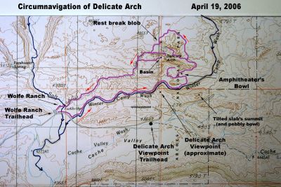
This mark-up of a topographic map shows the route of the circumnavigation in purple, watercourses in blue, hiking direction in red arrows, and reference points in black.
The map is actually parts of two neighboring topographic maps joined at the thin black vertical line just left of Delicate Arch. The "rest break blob" is almost on that line. The left map is USGS The Windows Section; the right one is USGS Big Bend.
There are two map errors near Delicate Arch Viewpoint:
1. the viewpoint trailhead (end of paved road) should be at the large black dot.
2. the road extending in an arc from the trailhead dot is not a road, but the lower part of the viewpoint trail.
. |