photo sharing and upload picture albums photo forums search pictures popular photos photography help login
Bryan Murahashi | all galleries >> Galleries >> 2015 PaD - When I Can > Flows to the Bay
previous | next
10-MAY-2015

Flows to the Bay

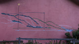
Found this profile map on the side of a building of the many creeks flowing into the South San Francisco Bay.
Having forgotten my GPS on this long hike, looks like we hiked 2056 feet to the top of Black Mountain.


other sizes: small medium large original auto
share
Alexander Kazakov29-May-2015 14:26
Nice capture! Good find! V
Dennis Hoyne27-May-2015 04:06
What fun place for a hike, and a neat way to document it!
Tom LeRoy26-May-2015 20:46
A neat relief map that is really nice, showing the water flow and altitude. Great hiking, Bryan! V
Chris Spracklen26-May-2015 20:23
Nice find and photo, Bryan.
laine26-May-2015 18:16
Thought provoking...especially that your able to climb that far and still be breathing LOL!!
Walter Otto Koenig26-May-2015 14:52
Very cool and unusual mural. "V"
Yvonne26-May-2015 11:28
What an interesting find... makes a fine image Bryan! v
Graeme26-May-2015 08:59
Great stuff and hike, Bryan!
joseantonio26-May-2015 05:07
That looks like a great hike.V
Tom Munson26-May-2015 04:52
Great find and cool shot, Bryan.