


|
|
|
|
|
|
| |
| 23-MAY-2014 | |
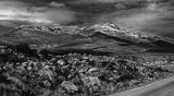
The Altiplano, (Spanish for “high plain”), is the most extensive area of high plateau on earth, outside of Tibet. It is a desolate, wind-swept, rock-strewn landscape, set amidst barren mountains. I made this image at an altitude of almost 13,000 feet. I anchor this landscape photograph by filling nearly the entire bottom half of the frame with rocks. They point to a distant valley, which rises towards a range of snow-spattered mountain peaks. I wanted to interpret this scene as a cold, high, threatening place (its altitude alone is enough to produce illness). Yet the green valley and the blue sky that peeked through the cloud cover were quite pleasing to the eye, diminishing the forbidding interpretation I wanted to create. When I converted this image to black and white, everything changed. The peaceful colors were replaced with grays, whites and blacks that emphasized the jagged field of rocks in the foreground and the mountains in the background. The monochrome valley becomes merely a transitional zone, not a destination in itself. The clouds in the sky suggest the threat of a storm. By including a slice of the highway in the lower right hand corner of the image, I contrast the work of nature to the presence of man, even here on this Altiplano, one of the most remote places on earth.
Image Copyright © held by Phil Douglis, The Douglis Visual Workshops