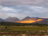
Rendalsĝlen is a majestic standalone mountain in Rendalen, Hedmark county, SE Norway. Here seen from the west by Skċnborket at sunset.
Its three peaks measures 1699m (north), 1755m (central), 1688m (south). Here you see the central and southern peaks.
The central main peak/1755m (left) is the 3rd best viewpoint in all of Norway!
FYI, here are geographical data for the 14 best viewpoints on the Norwegian mainland (Antarctica, Svalbard and Bjĝrnĝya excluded):
Name/height - land area visible - farthest point seen - distance and direction to farthest point
1. Gaustatoppen 1883m - 36538 km² - Hindnubben 1737m/Jotunheimen - 199.3 km/3.1°
2. Storsylen 1762m - 34489 km² - Storkalkinn 1880m/Sunndal -189.2 km/257.8°
3. Rendalsĝlen 1755m - 34142 km² - Ranastongi 1900m/Golsfjellet - 187.0 km/240.4°
4. Rondeslottet 2178m - 33487 km² - (possibly) Lievkiesċajja 1443m west of Östersund/Sweden - 194.1/40.1° km
5. Jiehkkevárri 1834m - 32591 km² (incl. some fjords) - mountain on Hinnĝya - 200.3 km/240.7°
6. Snĝhetta 2286m - 31427 km² - Olheia 633m/Fosen - 216.1 km/23.3°
7. Oksskolten 1916m - 28701 km² - (possibly) Ryggċsberget 1946m in Sarek NP/Sweden - 198.6 km/42.8°
8. Suliskongen 1908m - 28263 km² - Rĝst archipelago/Lofoten - 195.5 km/281.3°
9. Knutsholstind 2341m - 28068 km² - Paradiskollen 670m/Harestua - 183.2 km/138.3°
10. Tjĝrnholstind 2331m - 27971 km² - Blċenga 633m/Vċler -187.6 km/116.5°
11. Glittertind 2464m (2nd highest in Norway) - 25996 km² - Sĉtersjĝberget 590m/Odal - 199.6/122.1° km
12. Surtningssue 2368m - 25395 km² - Rughaugen 681m/Krokskogen - 183.2 km/146°
13. Blċhĝa 1671m/Trollheimen - 23371 km² - Geitfjellet 872m/Grong - 233.1 km/36.5°
14. Galdhĝpiggen 2469m (highest in Norway) - 23136 km² - Hummelfjell 1543m/Tolga-Os - 177.9 km/59°
The widest view coverage incl. the ocean (and thus not qualified for the above terrestrial list) on the Norwegian mainland (Antarctica, Svalbard and Bjĝrnĝya excluded):
Hermandalstind 1029m/Lofoten - 51605 km² (incl. ocean) - Kvasstind/1010m (the 2nd southernmost peak in the Seven Sisters) - 224.0 km/ direction not calculated
The longest sightline on the Norwegian mainland (Antarctica, Svalbard and Bjĝrnĝya excluded):
Kvasstind/1010m (the 2nd southernmost peak in the Seven Sisters) - Stjerntind 934m/Flakstadĝy in Lofoten - 237.8 km (across the ocean)/ direction not calculated
(btw, my pic #1000 at Pbase :)