


|
|
|
|
|
|
| |
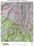
The red lines are lifts, except for the west one which is the Krusier Run (starting where paint brush splits off) on the west boundary of Timber Line (TL) ski area. (at least according to my GPS) The blue in the upper left is my "loop" trip. This would have been a loop if you count the ride up the Mile ski lift, and if I continued sking back to my car, instead of dropping down along the Sand Creek. That route is shown in green, including taking the Glade Alpine connector back (up) to the ski area. A couple of lifts later I went out of bounds again looking for Igloos we saw last Wednesday. That is also shown as a small green route. Looks like I just missed it when doing the "loop"
This "loop" combines what Klindt's book calls lower and upper Zig Zag, with a ski down the broad slopes between Little Zig Zag and Zig Zag. You might want to do the lower first so you know where the crossing is, and if the snow doesn't look good maybe go back inbounds to ski down.
All images are copyrighted, please request before using