


|
|
|
|
|
|
| |
| 19-AUG-2016 | |
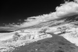
Kahikinui from Kaupo
Kaupo, Maui, Hawai'i
From Wikipedia: Kaupo is one of the districts of ancient Hawaii (moku in the Hawaiian language) of Maui island in Hawaii. Kaupo is a very remote and sparsely populated sustainable ranching community.
Location
Kaupo is located along the southeastern shore of Maui, west of Kipahulu along the Kahikinui coastline 20°38′33.28″N 156°7′51.60″W Coordinates: 20°38′33.28″N 156°7′51.60″W. Kaupo is located on a very rugged and desolate side of the island. The Kahikinui Forest Reserve is located in the area, as well as a section of Haleakalā National Park. A trail leads from near the summit of Haleakalā through Kaupo Gap.
Kaupo is connected to the rest of the island via the Pi'ilani Highway (Hawaii Route 31). The highway is primarily one lane wide and is not paved in all sections
History
The ancient district of Kaupo, before 1859.
Kaupo was "Wahipana" (Special Place) for ancient Hawaiians. In the early 1900s many families lived in Kaupo. Fishing, farming, hunting and ranching were primary occupations.[citation needed] In 1859 the district was combined with that of Hana.
The Loaloa Heiau and Huialoha Church are located in the district
All images are copyrighted and all rights reserved
Please login or register.