It still looks like a tip but most of it now lies under the waters of Lake Erie. A barrier has been set up to prevent people from walking onto what's left of it.
The following info is from a Windsor Star article published in 2007. "Point Pelee National Park is 8.5-kilometres long and attracts approximately 275,000 visitors a year with an estimated economic impact of $10 million annually.
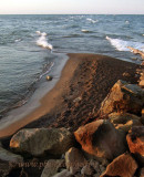
The southernmost tip of mainland Canada has disappeared and it may not return. The Point Pelee sand spit, which in 2000 stretched as much as a kilometre into Lake Erie, vanished this winter, along with a viewing platform and about 10 metres of vegetation. It's the longest time -- about five months -- the tip has been gone and now storms and erosion are attacking the park's trails and Carolinian forest.
One of Canada's smallest national parks is getting smaller. "The lack of sand doesn't just end at the tip. There is significantly less sand along both of the shorelines in the national park today than there was in the past," Zuzek (a consultant) said. "The tip is sort of the visible problem, but it's really just an indicator of an overall problem."
Park superintendent Marian Stranak said the narrow forested tip is a very fragile part of the park. It is about 200 metres wide where the tram drops off visitors to walk to the tip. The sandspit, about 50 metres long at times last year, has always changed as storms caused it to shift around in the lake like a dog's wagging tail. Stranak said the big difference is the erosion seems to be accelerating and it makes her wonder, "What's going to happen next?"
Weather, such as the severe storms and winds this winter, and changes along the shoreline such as harbours and shoreline protection, affect the tip. Zuzek lists a number of reasons for the tip's troubles. The sand off Point Pelee was mined from 1910 to 1984. An estimated 3.9 million cubic metres of sand and gravel was removed, enough to fill Toronto's domed baseball stadium, the Rogers Centre, more than twice. Without the sandspit, the sand, which is borne on currents created by waves, isn't accumulating at the tip. It keeps heading out into the lake, he said. - extract from the Windsor Star newspaper. To see complete article see: http://www.canada.com/windsorstar/news/story.html?id=2552244c-e7b8-4796-8f44-db561f0d095c&k=54219