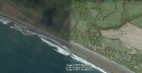
Composite hi rez GE photo, about 100 KM south of Manuel Antonio, why hi rez here?
More later on this site too.
The interesting thing that is so pronounced here is the left photo is at high tide, and the right side is low tide.
And really the beach is such a low grade here, that the tide exposes a lot of beach when its out.
Very slight slope, but there are other beaches with a sharp slope about 150 KM north.
Notice the black volcanic sand, if you take some up onto a towel or dish, let it dry out, its has so many colors that
you would be astonished. Under a mike, its lovely.
Notice the greyer colored water in a sort of circle extending out beyond the surf line, thats the undertow currents. If you get caught in one and washed way out, swim parallel to the beach till you get out of it. These are very dangerous in Costa Rica, we were in Manual Antonio nat park one time, when 3 American tourists all drowned, it was so sad.