


|
|
|
|
|
|
| |
| 30-SEP-2004 | Eric Noel |
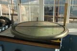
The Osborne Fire Finder is the traditional apparatus for locating fires. You line up the ruler with the target on the other end and the location of the metal strip over the fixed map gives the direction. I'm not sure how the distance or angle is calculated. Anyway, satellites and planes are used now although these things still work just fine if someone is around to use one. This pic might have been better if it were looking down from a little higher up to gives more of an angle showing the map.
All Images are Copyrighted by Eric Noel. All rights reserved.
| comment | |