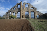
After getting thoroughly drenched I left the Aspendos terrain proper. I went to the part of the aqueduct I did not visit in 2012, and found from the main part standing one could walk into the direction of Aspendos on what first looked like a road, but quickly turned out to be the actual top of the aqueduct. A canal cut through the structure, but it went on on the other side. When walking back the weather improved so I could take some shots with the sun shining.
View Map should show where I was when taking the pictures.
I understand that the hump-back part is a "syphon" where the pressure of the water would bring up the water to some 30 meters, from where it would flow - probably a structure to better control its flow. If someone could explain that would be much appreciated.