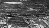
photo sharing and upload picture albums photo forums search pictures popular photos photography help login
Type your message and click Add Comment
It is best to login or register first but you may post as a guest.
Enter an optional name and contact email address. Name
Name Email
help private comment
Don Boyd | all galleries >> Memories of Old Hialeah, Old Miami and Old South Florida Photo Galleries - largest non-Facebook collection on the internet >> 1950 to 1959 Miami Area Historical Photos Gallery - click on image to view > 1956 or 1957 - The western portion of Miami International Airport, Dressel's Dairy Farm and undeveloped land
previous | next
1956 or 1957

1956 or 1957 - The western portion of Miami International Airport, Dressel's Dairy Farm and undeveloped land

West of Miami Airport, Dade County, Florida


This is amazing to view and realize how things used to be before every square inch was paved over with warehouses, stores, homes, etc. Milam Dairy Road used to be lined with trees and was a visual pleasure to drive on. Developers have managed to turn it into one of the ugliest congested roadways in the county now.


other sizes: small medium original auto
comment | share
Don Boyd11-Nov-2013 06:01
Guest from 30-May-2013: Great story and I apologize for the delay in responding. From what I've seen at MIA I believe it, but the captain was taking a hell of a chance of losing his license if he got caught. Fortunately everything worked out. Thanks for posting!

Guest from 11-Nov-2013: I thought it did exist where it went under Milam Dairy Road and I'll have to check the next time I'm in the area. Although you may not see the canal on the surface in various locales, the canal could be underground enclosed in a huge pipe. I know for a fact that this canal was enclosed in a huge pipe running east-west through Miami International Airport north of former runway 9L-27R (now 8R-26L) and the former taxiway Lima from the west side of the airport to LeJeune Road. I did a brief search for canals in the area and there is a S26 canal still on the maps that matches the canal in the above photo. It is one of the South Florida Water Management District canals that drains water in the western part of the county to Biscayne Bay and they have pumps to push the water eastward.

Don
.
Guest 11-Nov-2013 00:53
That canal does not exist today I believe
Guest 30-May-2013 14:05
Gilbert and Don...here is an "infamous" story. in the early 70's say 1971, I was a 6 year old kid taking a "hop" to the islands to meet up with my folks who were vacationing. I flew on a DC3 cargo flight out of MIA. When I boarded there was a crusty old gentleman who introduced me as the Captain. He invited me to the cockpit and told me what I at the time...and for years later till I went to flight-school still believed was...a tall-tale. As we were the only to souls on-board, he told me he would have me ride in the cockpit right seat. He then proceeded to put a box on the seat, sit me in it and strap me in. He then said that he was supposed to have a co-pilot on this flight but that he was sick and I'd have to fill-in. He then put a pilots hat and head-set on me saying that was for the benefit of the control tower so they'd see two pilots. It was a wonderful experience. When I arrived and told this to my parents they both laughed and said the pilot was just "pulling my leg". As it turns out he was not. I found out years later that DC#'s on commercial flights were required to have an aircrew of two. Aghh the good old days....
Don Boyd23-Mar-2010 04:04
Galen, I'm sorry but I don't have any access to those old records for the cargo buildings. The only thing I can suggest is to contact the Miami-Dade Aviation Department's Properties Division and see if they have the old leases in their archives that would mention the square footage and possibly the dimensions.

Don
Galen Frederick 23-Mar-2010 01:11
Mr. Boyd, I am trying to get the dimensions on the three original cargo buildings in this photo for a 1/144 scale diorama project. Can you help with that sir?
Regards, Galen Frederick.
Don Boyd27-Jul-2009 10:08
It was infamous because of all the cargo airlines that operated out of there, the wide variety of characters involved with those airlines and perhaps some shady maintenance practices on the old aircraft that flew the cargo. Throw in a bunch of crusty fly by the seat of your pants pilots, co-pilots and flight engineers, some of them sober and some of them not, and you have a scenario that was not duplicated anywhere that I know of.

Don
Gilbert Suarez 27-Jul-2009 00:43
Why is MIA's northwest corner infamous? Is that the corrosion corner i have heard about?
Don Boyd10-Sep-2008 04:55
Good guessing Ray. Since I put this photo up I've had a couple of old-timers tell me about the Seaboard railroad splitting the northern half of what is MIA now from the rest of the airports south of the track.

The photo athttp://www.pbase.com/donboyd/image/97866432 identifies it as the Seaboard RR tracks and I modified the above photo to state that.

When the tracks in the photo were closed to combine the airports into MIA, they were extended south and just west of LeJeune initially at the eastern end of this runway (former 9L-27R, now 8R-26L). The tracks proceed along the canal southbound and end up on the east and south sides of Perimeter Road going west. A few tracks then curve southbound under 836 and another couple of tracks go west around the long south runway (9-27) and then curve back east following the airport fence and then go north and under the overpass at 36th Street. These tracks, Perimeter Road and Milam Dairy Road were moved westward when the south runway (former 9R-27L, now 9-27) was extended from 9300 feet to 13,002 feet in the early 80's. That is the runway that goes almost all the way to the Palmetto, not the north runway depicted in this photo.

The north runway (former 9L-27R, now 8R-27L) depicted in this photo was only extended a couple hundred feet from what is seen in the photo above. The current end of the runway is due south of the eastern end of the building to the right of the word "yet" on the photo. All of those cargo buildings have been demolished for new construction but I remember where it was because I used to photograph landing aircraft at that location for many years.

Don
Ray10-Sep-2008 03:19
I've been trying to figure out what you have labeled as ? road or railroad. From very slight curve, I'm pretty sure that was a railroad bed. I've been trying to place everything in my mind. I'm guessing NW 25th St was the southern border of the whole airport at one time. The rails that enter the airport now at LeJune and 30th St. likely went due west right next to this runway until they did the curve south to 25th St and 67 Ave. So I think the runway went right on top of this railroad bed. They must have rerouted the railroad to make the runway. But did they move it to where it is today along the 836 or somewhere else first? Some other aerial shots of the airport back then would likely confirm this. Like old runways, old railroad beds sometimes show up in aerial photos years after they disappear on the ground. In current aerials at maps.google.com I sort of see something just west of LeJune at 30th, but not enough to confirm that the rails went west. Still interesting to try to figure out where things were back then and how they've moved to make way for the airport's expansion.

As for this runway's expansion, I remember it going to just 72 Ave, so that's way more than this photo shows. Now it almost touches the Palmetto at 77 Ave. Just the expansion is almost the entire height of this picture.
Don Boyd06-Aug-2008 08:29
Hi Martha old friend (sorry about the delay in scanning the post cards), yes, and it is labeled above with an arrow pointing down to it. It was a block or two south of the canal on Milam Dairy. Are you saying that is not Dressel's Dairy? Because it sure looks like it as I recall it and someone who worked there says that's it.

Don
Martha Pierson 06-Aug-2008 06:01
Don,
Dressel's Dairy was off of 72nd Av and about 28th street. When we used to go there
from Miami Springs we took Perimeter Road to 25th st and then went n on 72nd Av
to the Dairy.
Martha 03-Jul-2008 00:38
The two buildings in the lower left hand side are airline maintenance bldgs. The long bldg was Aerodex/PanAm maintenance shop and the small one to the west was Eastern Airlines Test Cells. The test cells were used for repair and testing prop engines.