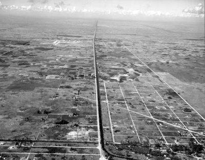
photo sharing and upload picture albums photo forums search pictures popular photos photography help login
Don Boyd | all galleries >> Memories of Old Hialeah, Old Miami and Old South Florida Photo Galleries - largest non-Facebook collection on the internet >> 1940 to 1949 Miami Area Historical Photos Gallery - click on image to view > 1947 - Tamiami Trail (US 41) looking west with Tamiami Airport on the left of it in the background
previous | next
1947 Courtesy of George W. Young

1947 - Tamiami Trail (US 41) looking west with Tamiami Airport on the left of it in the background

Dade County, Florida


The original Tamiami Airport is now the site of Florida International University (FIU) which opened in 1972. The airport was replaced by the New Tamiami Airport which is further south. New Tamiami evolved into Tamiami Airport over the years. In the early 90's Tamiami Airport was renamed as Kendall-Tamiami Executive Airport to placate the Kendall homeowners who moved out there decades after the airport was built only to complain about the airplane noise.


other sizes: small medium original auto
comment | share
Mark Lincoln 23-Apr-2015 23:46
I remember doing a touch and go at old Tamiami airport the last day it was open in either December 1967 or early 1968.
Joe Papierz Jr. 27-Jul-2014 03:49
I drove West from Miami to Naples on Tamiami Trail about a year ago. I bears no resemblance to this photo at all. It's stop and go nearly half way across the State because of the neighborhood build up with many shopping centers. It's no longer the ride in the country it used to be.
Don Boyd10-Jul-2009 05:37
I don't believe the canal name was in question. Barry was elaborating about the Miami Canal, which borders Okeechobee Road / US 27, wiping out the South Fork of the Miami River and the lake system south of MIA was tied into the South Fork of the Miami River. The lake system is connected to the Tamiami canal via the canal that runs along the east side of the Palmetto. It sounds totally logical to me and I didn't know about the South Fork / lakes south of MIA connection before he wrote in.

Don
Charles Knight 10-Jul-2009 02:58
I am from Sweetwater and the canal in question is the Tamiami Trail canal. Yes it was dredged for fill used to create theTamiami Trail (US 41) It was never intended as drainage. I learned to swim there at the old bridge on 107th Ave.in the early sixties, My father was Chief Jack Knight of the Sweetwater Police Dept. for more than two decades.
Barry Diamond 08-Jul-2009 21:41
The photo starts at about 75 Ave. looking west. The lakes south of MIA are the runoff pools of the South Fork of the Miami River. The South Fork was all that remained of the original river after the Corps of Engineers dug the Miami Canal as part of the Everglades drainage. The lake system ties into the Tamiami Canal and Snapper Creek. The link runs parallel to the Palmetto Expressway on the East. Prior to the Corps work in 1914, the Everglades extended into Dade up to what is now 27th Ave. (SR#9). There was a slight elevation in the Glades that caused a small rapids effect as it spilled into the original Miami River.
GUEST 25-Feb-2008 01:37
I think that the diagonal road is FLAGAMI BLVD.
Ray26-Oct-2007 01:08
I've been trying to compare this to today. I'm going to assume that the canal on the right side was dug just to get fill for the road. That canal comes from the west and now ends at the Palmetto, SW 77 Ave. I assume the rest was filled in to make it easier to make intersections. There appears to be a new canal going from 77 Ave, NE on a curve towards the lakes south of the airport. Were those lakes made to get fill for the airport? Another branch goes towards the Gables, then seems to more naturally wind through the Gables? Was this man made or natural?

I think a bunch of canals were built in Dade after the 1947 and 48 Hurricanes. Maybe this one was phased out.

I know, even today, a heavy rain swamps Sweetwater. With this canal to the ocean cut off and diverted, I think I can see why.

I'm thinking the diagonal line going from NE to SW is the start of Beacon Blvd/SW 22 Ave Rd.

Ray
Guest 01-Jun-2007 15:54
They are the cousins of the maroons who buy next to a train track and then complain about the trains.
Guest 25-May-2007 23:37
The next time there is a meeting held somewhere about airport noise they need to ask all the people who moved in after the airport was built to stand up and leave. They knew they were buying property near an airport so this does not concern them. The folks who lived there before the airport have a say.
Richard Dalkranian.