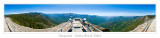
(_LND0913-0938 Panorama.jpg) This is not the best, as I have misalignments on the railings when the pano was stitched together. Some day I'll work on a better version. This is a full 360 degree view from the top of the trail. The road you see on the right side of the frame is highway 198 leading to the park's south entrance (Ash Mountain Entrance). Not many people made this hike all the way to the top, it was a hard one with a 300 foot climb up 400 steps twisting to the top. Click on the original link below to see the full size copy.